Tricky winds with a new swell for later tomorrow, large early next week

Western Australia Surf Forecast by Craig Brokensha (issued Wednesday August 16th)
Best Days: Perth and Mandurah tomorrow morning, all locations Friday morning, Saturday morning in the South West (small across metro locations), Sunday morning Perth and Mandurah for a small wave, Monday and Tuesday
Features of the Forecast (tl;dr)
- Large SW groundswell building tomorrow afternoon, more so later, easing Fri
- Strong but easing SW tending S/SW winds in the South West tomorrow, S/SE-SE to the north in the AM
- Light S/SW winds Fri AM, possibly S/SE-SE, offshore to the north
- Smaller, easing surf Sat with variable winds ahead of sea breezes, light E to the north
- New moderate sized + SW groundswell Sun with strengthening W/NW winds, light E/NE to the north
- Large SW groundswell building Mon with S/SE-SE tending S/SW winds, easing Tue with variable offshore winds ahead of sea breezes
Recap
Poor conditions across most locations yesterday, though Perth saw a window of light winds through the morning and lumpy 2-3ft waves. A large SW groundswell due through the day built to a decent size in the metro regions but failed to really get to any major size in the South West.
Today we've got a mix of easing SW groundswell and localised S/SW windswell with strong S'ly winds across all locations, favouring protected spots. The South West is in the 8ft range with 3-4ft sets across Mandurah, 3ft in Perth.
Also be aware a decomposing whale has washed up in Mandurah between Falcon and Halls Head, sharks will be active.
This week and next (Aug 17 - 25)
This morning's brief respite in winds will deteriorate into the afternoon as the next swell producing front pushes in, bringing a shift to the S/SW-SW.
A great fetch of gales have been generated through our south-western swell window, with a large reinforcing SW groundswell due to fill in later tomorrow afternoon across the South West, peaking Friday morning to the north.

Size wise 8-10ft waves are due in the South West, easing back from the 8ft+ range Friday morning with 2-3ft sets in Mandurah and 2ft waves across Perth.
Strong but easing SW tending S/SW winds are due in the South West tomorrow, S/SE-SE to the north with lighter S/SW winds in the South West Friday morning that may tend S/SE-SE for a period in the morning.
Variable winds are due into Saturday morning across the South West as the swell continues to ease, light E'ly to the north, while Sunday looks poor as winds strengthen from the W/NW through the day (light E/NE to the north in the morning) thanks to the next approaching frontal system.
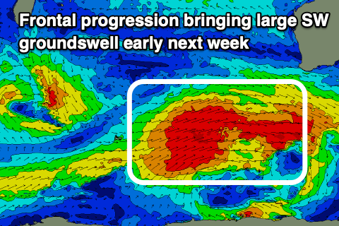
This frontal progression will bring an oversized SW groundswell early next week, but it's worth noting ahead of it on Sunday a new, moderate + sized mid-period swell is due, generated by pre-frontal W/NW-NW gales ahead of the main progression from this afternoon through Friday.
We should see the South West building to 6ft+ with 2ft sets in Mandurah and 1-2ft waves in Perth through Sunday but with those deteriorating winds.
The stronger frontal progression will develop to the west of the Heard Island region today, with a broad fetch of sub-gale-force winds moving slowly east, reaching gale-force strength once across Head Island.
We'll then see a slow rolling fetch of W/SW gales moving east, producing a large, consistent SW groundswell that will fill in Monday, building rapidly to a peak into the afternoon around 10-12ft in the South West, 3-4ft in Mandurah and 3ft across Perth.
Winds could be favourable as a high moves in behind the frontal progression, bringing S/SE-SE breezes to all locations ahead of afternoon sea breezes.
Tuesday also looks clean with variable offshore winds and easing surf but we'll review this again Friday.