Onshore tomorrow, cleaner late week

Western Australia Surf Forecast by Craig Brokensha (issued Monday August 7th)
Best Days: Wednesday, Thursday and Friday morning in the South West, Saturday in the South West, Sunday and Monday mornings Perth and Mandurah
Features of the Forecast (tl;dr)
- Mix of mod-large W/SW swells for tomorrow and Wed AM, easing later and more so Thu
- Strong NW tending W winds tomorrow (N/NE for a short window early to the north)
- Light E/SE tending variable winds to the north Wed, S/SE-S tending weak sea breeze in the South West
- Light E/NE winds and weak sea breezes Thu
- Smaller Fri with light offshore winds and weak sea breezes
- Moderate sized mid-period SW swell for Sat with a larger S/SW swell building late Sat, peaking Sun
- Increasing S/SW-SW winds Sun, offshore to the north in the AM
- Easing swell Mon with strengthening W winds
Recap
A temporary low point in swell across the South West though still 2-3ft in Mandurah and 2ft across Perth Saturday morning with nice clean conditions. Into the afternoon the swell started to kick out of the SW, with a large peak in size yesterday morning to 8ft+ with great conditions. Mandurah was 3ft and Perth 2ft, building through the day.
This morning, yesterday's swell is on the ease with deteriorating conditions across the South West as a front clips us, better to the north.
A reinforcing pulse of mid-period W/SW swell is due this afternoon, discussed in more detail below.
This week and weekend (Aug 8 - 13)
As yesterday's strong SW groundswell from a polar low late last week eases, a secondary weaker but more northerly positioned frontal progression has generated a reinforcing pulse of moderate-large W/SW swell for this afternoon and tomorrow morning.
We should see the South West coming in around 6-8ft with 2-3ft sets in Mandurah and 2ft waves across Perth but with poor conditions thanks to a strong NW tending W'ly wind. There's a chance for an early window of N/NE winds to the north but conditions will be generally average.
The weak frontal system bringing tomorrow's change isn't expected to generate much in the way of swell, with some background W/SW energy likely to maintain 6ft to occasionally 8ft sets on Wednesday morning in the South West, 2-3ft across Mandurah and 2ft in Perth, easing slowly later and more so Thursday.

Winds will improve Wednesday as the front clears with offshore E/SE winds to the north in Perth and Mandurah, variable S/SE in the South West ahead of weak sea breezes.
Thursday should be clean with light E/NE offshore winds ahead of weak sea breezes and easing 6ft waves in the South West, 2ft Mandurah and 1-2ft across Perth.
From later in the week and more so through the weekend, building levels of mid-period SW tending S/SW swell are due thanks to a healthy polar frontal progression firing up just east of the Heard Island region.
Strengthening fetches of strong to gale-force W/SW winds will fire up in our swell window, with the strongest front due to fire up Thursday evening to our south-southwest.
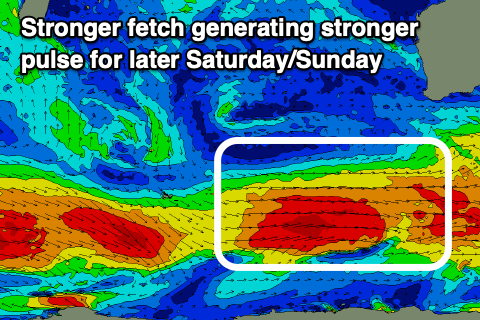
This should produce moderate levels of mid-period SW swell for Saturday morning, with a bigger better pulse due into Saturday afternoon, easing Sunday.
The best pulse should peak to 6ft to occasionally 8ft across the South West, 2ft+ in Mandurah and 2ft on the sets across Perth Sunday, with local winds due to be favourable Saturday, less so Sunday. Morning offshores winds are due to give into weak sea breezes Saturday with a trough bringing increasing S/SW-SW winds on Sunday (offshore to the north in the morning).
Longer term we're looking at some stronger Southern Ocean activity into the weekend and larger surf next week but with tricky winds. More on this Wednesday.