Average period with tricky swells and winds

Western Australia Surf Forecast by Craig Brokensha (issued Monday May 29th)
Best Days: Perth and Mandurah Wednesday morning, Saturday selected spots in the South West
Features of the Forecast (tl;dr)
- Strong NW winds tomorrow with a building mid-period W/SW swell, easing Wed (N/NE winds to the north, tending NW)
- Easing W/SW swell Wed with W tending S/SE winds (E/NE-NE to the north)
- Small mix of S/SW swells easing Thu with fresh S/SE winds
- Smaller Fri with E/SE winds ahead of sea breezes
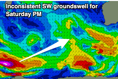
- Inconsistent SW groundswell building Sat with gusty E/NE tending NE and then N/NE winds
- Easing swell Sun with strong N/NE tending N winds
- XL stormy surf for next week
Recap
The surf was small and clean across the South West Saturday, fading while locations to the north were tiny.
Yesterday was average with a weak but easing W'ly wind but large new S'ly groundswell which peaked through the day. To the north some new swell kicked into the afternoon, with slow easing 1-2ft sets on offer this morning. The South West was 4-6ft at dawn but now on the ease.
This week and weekend (May 27 – Jun 2)
The coming week is a funky one, and after the past month or so of pumping waves, it looks like we'll be entering a transition period with strong frontal activity due to develop through next week.
Firstly, tomorrow will be poor with strong NW winds in the South West and N/NE winds to the north but with no significant swell.
A deepening trough will see winds holding out of the W on Wednesday morning, though shifting S/SE through the day in the South West and tending light E/NE-NE to the north as it drifts east. There should be a small to moderate sized pulse of mid-period W/SW swell in the mix, generated on the weekend to the north of the Heard Island region.
Size wise there's nothing major to it with 1-2ft sets in the north and 4ft+ waves to the south, smaller Thursday along with a weak S/SW swell generated by the southern flank of the trough. There'll also be some small swell generated by a late forming polar frontal system to our south today, easing through Friday.
Winds will unfortunately persist from the S/SE on Thursday, providing no quality options.
Friday looks a bit cleaner with an E/SE offshore but though small, easing mid-period S/SW swell from 3ft.
Saturday looks the pick of the period for me, with a new inconsistent S/SW groundswell due to arrive along with offshore E/NE tending NE winds, N/NE later.
The groundswell is being generated by a strong but distant polar low south-east of South Africa. A fetch of severe-gale to storm-force W/NW winds are being generated, and we should see slow, inconsistent sets to 4-5ft on the magnets into the afternoon when it peaks, easing Sunday with strengthening N/NE winds.

Now this strengthening breeze will be ahead of a significant and sustained progression of mid-latitude frontal systems pushing up and into us next week.
It looks like this progression will be quite significant, generating an XXL W/SW groundswell for mid-next week along with strong to gale-force onshore winds from the W/SW.
There'll be nowhere really to hide from this wind and swell with novelty spots the only option but we'll have a closer look at this on Wednesday.