So-so weekend, better early/mid next week

Western Australia Surf Forecast by Craig Brokensha (issued Friday January 13th)
Best Days: Semi-protected spots in the South West tomorrow, more exposed spots in the South West Sunday morning, Tuesday, Wednesday and Thursday mornings in the South West
Features of the Forecast (tl;dr)
- Small-mod sized pulse of mid-period SW swell tomorrow with strong SE-S/SE tending S/SE winds
- Easing swell Sun with mod-fresh E/SE tending S/SW winds
- Small mid-period SW swell for Mon with strong S/SE winds
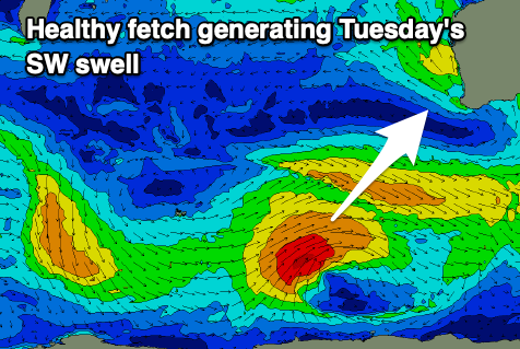
- Mod-large SW swell for Tue with gusty SE tending S/SW winds
- Easing swell Wed with gusty E/SE tending S/SW winds
- Fading surf into the end of the week
Recap
Great conditions with a smaller, easing swell from 3-4ft in the South West, 1-1.5ft across Mandurah and 1ft in Perth.
Today the swell was a similar size but with less than ideal winds across Margs and Mandurah, clean and peaky in Perth but only to 1-1.5ft.
This weekend and next week (Jan 14 - 20)
A pulse of reinforcing mid-period SW swell due through tomorrow across the South West has been upgraded a little, with the front attached to it generating a slightly better fetch of strong SW winds, directly south-west of us today.
This should pulse to 4-5ft through tomorrow morning in the South West and 1-1.5ft in Mandurah but remain tiny across Perth. The swell is due to ease into the afternoon with smaller, easing 3-4ft sets Sunday morning.
Winds tomorrow will be strong and S/SE-SE in the wake of a trough moving through this afternoon, better Sunday morning with weaker, moderate to fresh E/SE breezes through the morning.
Another trough will bring a change into Sunday evening, with winds shifting back to the S/SE through Monday morning along with some new mid-period SW swell.
This first pulse of mid-period swell looks to be smaller than Saturday's with a weak, pre-frontal fetch of W/NW winds around a polar low due to maintain 3-4ft sets across the South West magnets, tiny elsewhere.
A better fetch of strong to gale-force W/SW-SW winds around the centre of the low should produce a bigger and stronger pulse of SW swell for Tuesday, with good sets to 6ft+ across the South West during the morning, with Mandurah building to 2ft+ and Perth 2ft on the sets.
Those less than ideal S/SE winds on Monday are due to shift strong SE into Tuesday morning. This isn't ideal for the South West but semi-protected spots will be the go.
Wednesday looks cleaner with a gusty E/SE wind and easing swell with a bit more south in the direction, dropping from 4-5ft in the South West, tiny to the north.
Unfortunately there's no significant swell to follow into the end of the week with the easing trend due to continue into Thursday and Friday but with morning E/SE winds.
Longer term there's nothing showing on the charts to make the most of the swell into early next week. Have a great weekend!