Easing surf ahead of more activity into the weekend

Western Australia Surf Forecast by Craig Brokensha (issued Monday January 2nd)
Best Days: Exposed spots tomorrow morning in the South West and the swell magnets Wednesday morning, protected spots Sunday morning, Monday morning, Tuesday morning
Features of the Forecast (tl;dr)
- Final pulse of moderate sized mid-period S/SW swell tomorrow AM with gusty E/SE tending strong S/SE winds, smaller Wed with gusty E/SE winds ahead of sea breezes
- Moderate sized + building mid-period swell Sat PM, peaking Sun AM
- Strong S/SE winds Sat mod-fresh S/SE tending S/SW Sun
- Large SW groundswell for Mon AM with gusty SE tending strong S/SE winds
- Easing surf Tue with gusty SE winds
Recap
Smaller, bumpy surf on Saturday ahead of a good pulse of new mid-period SW swell into the afternoon, better yesterday though only in protected spots with early cross-offshore winds. Perth and Mandurah were tiny Saturday, better yesterday but to only 1-2ft (a little under expectations)
This morning was cleaner across the South West but with a dropping swell from 4-6ft this morning, 1-2ft in Mandurah and 1ft across Perth.
This week and weekend (Jan 3 - 8)
The surf will slowly ease over the coming days, slowed in the South West tomorrow by a reinforcing mid-period S/SW swell that was generated by a weak final front projecting towards us on the weekend.
The South West should be 4-5ft tomorrow morning but tiny further north in Mandurah/Perth and to 1-1.5ft. Winds look to be best for slightly-protected spots and out of the E/SE-SE, gusty through the morning ahead of strong afternoon S/SE winds (S/SW Perth and Mandurah).
Wednesday will become smaller but conditions clean again through the morning with gusty E/SE winds, smaller again Thursday with straighter E'ly offshore winds.
A trough moving through Friday will bring a change, possibly variable at dawn and size wise, there'll only be some small background swell in the mix across the South West.
This trough will be attached to a strengthening polar frontal progression firing up to our south-west, with back to back lows due to develop.
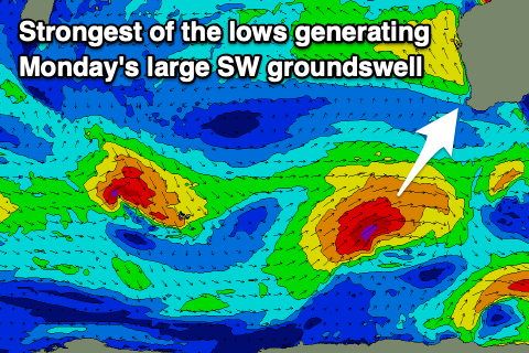
The first will be weakest, generating a mid-period SW swell for later Saturday but more so Sunday while the second will generate a fetch of gale to severe-gale W/SW-SW winds through our south-western swell window.
The first swell should come in around the 6ft range across the South West, 2ft in Mandurah and 1-2ft across Perth. The second swell looks great and to 8-10ft in the South West, 2-3ft across Mandurah and 2ft in Perth.
Locally winds will start to improve on Saturday as a high moves in but with strong S/SE breezes, weaker Sunday and moderate-fresh S/SE, best on Monday and more SE through the morning.
We'll review this again on Wednesday though.
Comments
What is with all the Perth surf cams offline?
Power outage, fixed now.
thanks :)
Intense rain in Broome.
It looks serious.
Very very serious RC