Swells and winds ebb and pulse

Western Australia Surf Forecast by Craig Brokensha (issued Monday August 15th)
Best Days: Perth and Mandurah Wed AM, early Thu and Fri AM, all locations Saturday and Monday
Features of the Forecast (tl;dr)
- Building mix of moderate sized W'ly swells tomorrow with strengthening W/NW winds
- Easing W'ly swell Wed AM ahead of a spike of new swell for Perth and Mandurah later PM
- Fresh W/SW tending strong S winds in the South West Wed, variable tending gusty S/SE then S/SW in Perth and Mandurah
- Moderate-large W/SW swell for Thu (more so PM for Margs)
- Lingering SW winds in the South West Thu, early NE Perth and Mandurah
- Easing W/SW swell Fri with W/NW winds in the South West, E/NE-NE Perth and Mandurah
- Mid-period SW swell for Sat with E/NE tending NW winds
- Easing surf Sun with S tending SW winds
- Mod-large SW groundswell Mon with gusty SE winds
Recap
Windy, small surf to kick off the weekend ahead of our large W/SW groundswell yesterday. Margs was bumpy, lumpy and average with lingering onshore winds but Perth and Mandurah provided better conditions with more variable winds and solid 3ft sets across Mandurah and 2-3ft waves in Perth.
Today the swell was similar in Perth and Mandurah with early clean conditions, now choppy with a strengthening onshore breeze. Margs was still large but choppy.
This week and weekend (Aug 16 - 21)
There'll be a temporary low point in swell tomorrow morning ahead of some new building mid-period W'ly swell and local windswell as a cold front pushes into us.
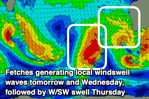 This front isn't overly strong, with it strengthening off a surface trough, but behind it we'll see a better fetch of strong to gale-force W/SW winds projecting up and then pushing north of our regions on Wednesday.
This will generate a moderate to large mid-period W/SW swell for Thursday, peaking into the afternoon.
But coming back tomorrow and strengthening W/NW winds will create poor conditions with the building windswell, remaining average as winds shift W/SW but ease on Wednesday. Perth and Mandurah may see early variable winds ahead of a gusty S/SE change as a ridge of high pressure moves in from the west. Size wise sets to 3ft are due across Perth and Mandurah with 6ft+ waves in Margs.
Thursday morning looks tricky with lingering SW winds across the South West and early NE winds to the north. The mid-period swell should be coming in around 3ft across Perth and Mandurah, while the South West should build to 6-8ft.
Unfortunately onshore winds will continue to linger across the South West on Friday as the mid-period W/SW swell eases, E/NE-NE in Perth and Mandurah but with easing 2-3ft sets.
Finally, from the weekend onwards higher pressure will start to edge in from the west more and across us, bringing improving conditions and winds for the Margaret River region. Swell wise some moderate sized, mid-period SW swell is expected Saturday ahead of a better groundswell Monday, with the latter being the day to target.
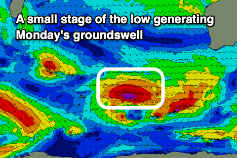 Saturday's swell will be generated by strong W'ly winds skirting around the southern flank of the high, with Monday's produced by a stronger, more southerly positioned polar low.
Variable E/NE winds are due on Saturday with 5-6ft sets across Margs, 2ft+ in Mandurah and 2ft in Perth, a little smaller Sunday with less favourable S'ly tending SW winds owing to a trough sliding through.
Monday's swell should come in around the 8ft range along with stronger SE breezes in the South West, with 2-3ft sets in Mandurah and 2ft waves across Perth. The blocking effects of the high are due to be seen through the week with easing surf as winds shift more east and then north-east. More on this Wednesday though.