Improving conditions with moderate swells

Western Australia Surf Forecast by Craig Brokensha (issued Monday April 18th)
Best Days: Tomorrow morning, Wednesday morning, Thursday in the South West, Friday from late morning South West magnets
Features of the Forecast (tl;dr)
- Mid-period, moderate sized + SW swell building tomorrow, peaking Wed with light SE tending strong S/SW winds tomorrow, moderate E/SE tending stronger S/SE Wed
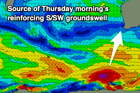
- Moderate sized S/SW groundswell Thu AM, easing with fresh E/SE tending strong SE winds
- Easing surf Fri and bottoming out on the weekend with strong E tending variable winds
Recap
Plenty of swell and size on Saturday across the South West but with bumpy conditions, still solid yesterday with lumpier options. Perth and Mandurah were in the 1-2ft range, cleanest across Mandurah yesterday but decent every morning in Perth.
Today the South West is cleaner with a mix of easing SW groundswell and mid-period S/SW swell with sets to 5-6ft, 2ft+ in Mandurah and 1-2ft across Perth.
This week and weekend (Apr 19 - 24)
Looking at the period ahead and we've got a great run of offshore, clean conditions across the South West but swell wise, surf in the moderate range rather than large.
 Into tomorrow morning we'll see the surf ease temporarily ahead of some new mid-period SW swell into the afternoon and Wednesday, generated by a great pre-frontal fetch of W/NW winds attached to a strengthening polar low.
The peak of the mid-period energy looks to be Wednesday morning but through tomorrow we should see sets to 4-5ft through the morning, kicking to 5-6ft later and holding around 6ft on Wednesday. Perth and Mandurah should maintain 2ft sets but be more so 1-2ft tomorrow morning.
A light SE offshore is due across the South West tomorrow morning, E/SE further north ahead of S/SW sea breezes, cleaner Wednesday with an E/SE offshore breeze, stronger S/SE into the afternoon,
Looking at the polar low and unfortunately it looks to form mostly too far east of our swell window to generate any major size, with a fetch of severe-gales producing a moderate sized, reinforcing S/SW groundswell Thursday morning to 4-5ft+ in the South West, easing during the day. Perth and Mandurah are likely to ease from a tiny 1-1.5ft.
 Winds will remain favourable and E/SE Thursday morning, stronger SE into the afternoon with a strong high moving slowly east through Friday and the weekend, bringing stronger E winds, variable into the afternoons.
Unfortunately the blocking effects of the high will see the swell bottoming out into the weekend with these strong offshore winds.
Looking longer term and the scope and broadness of the high will continue to suppress any major storm activity into the start of next week. A trough looks to deepen into a mid-latitude low far west of us later this week but only a small W'ly swell is due off this system. Longer term the outlook isn't ideal with troughy weather and no major Southern Ocean storms. More on this Wednesday.