Fun mornings of surf ahead

Western Australia Surf Forecast by Craig Brokensha (issued Wednesday January 26th)
Best Days: This morning, Friday (later protected spots with the new swell), Saturday morning, Sunday morning protected spots in the South West, Tuesday
Features of the Forecast (tl;dr)
- Late increase in small, mid-period SW swell tomorrow, peaking Fri AM with E/SE tending strong S-S/SW winds
- Late increase in larger SW groundswell Fri, easing Sat with fresh SE tending S-S/SW winds, E/NE in Perth and Mandurah during the AM
- Easing swell Sun with mod-fresh S/SE winds in the AM and PM sea breezes, smaller Mon with gusty morning SE winds
- Small mid-period S/SW swell Tue AM with E/SE tending S/SW winds
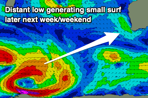
- Inconsistent, mid-period SW swell for later next week/weekend
Recap
Good waves across the South West yesterday morning with Monday's swell easing from 3-5ft, back to a 3ft today with workable SE winds. Perth and Mandurah were tiny and peaky to 1-1.5ft yesterday, only 1ft today.

Fun leftovers today
This week and weekend (Jan 25 - 31)
Tomorrow will remain small to tiny ahead of some new mid-period swell late in the day, though peaking Friday ahead of our larger groundswell later Friday and Saturday morning.
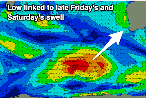
The mid-period swell was generated by a weak frontal system ahead of a much stronger polar low which is currently generating a great fetch of gale to severe-gale W/SW winds just east of the Heard Island region.
 The mid-period energy looks to come in at 3-5ft on Friday across the South West while Perth and Mandurah remain tiny and to 1ft.
Winds look great and moderate out of the E/SE on Friday morning before sea breezes kick in.
Looking at later Friday's and Saturday's swell and there's no change to the expected size with the swell likely to kick to 6ft+ across the South West Friday but with sea breezes, easing from a stronger 6ft to occasionally 8ft on the sets Saturday morning with 2ft waves in Mandurah and 1-2ft sets across Perth.
Winds won't be as favourable for the South West Saturday but still decent and moderate from the SE (possibly tending E/SE across some regions) with E/NE winds in Perth and Mandurah. Afternoon sea breezes will create average conditions into the afternoon.
Sunday unfortunately looks less ideal again with moderate to fresh S/SE breezes in the South West ahead of afternoon sea breezes with the swell easing back from 3-5ft. Perth and Mandurah look to remain tiny.
 The swell will bottom out into next week as winds swing more offshore owing to a strong, broad high pushing in and under the country. Swell wise a weak, small, reinforcing pulse of mid-period S/SW swell is due later Monday and Tuesday, slowing the easing trend. We're only looking at 3ft+ sets across the South West magnets Tuesday morning, easing through the day with an E/SE-SE offshore wind.
Longer term there's still nothing major on the cards, with inconsistent levels of mid-period swell due late next week and into the weekend from a broad, slow moving low firing up south-east of South Africa. Winds look favourable Friday and next weekend but size wise it looks to be in the 4ft range across the South West. More on this next update.