Slower week with varying winds

Western Australia Surf Forecast by Craig Brokensha (issued Monday September 20th)
Best Days: South West swell magnets tomorrow morning, Friday morning all locations, Saturday in the South West
Features of the Forecast (tl;dr)
- Easing S/SW groundswell tomorrow with fresh E/NE tending lighter N/NE winds
- Small, inconsistent SW groundswell building Wed with NE tending NW winds
- Mix of small swells Thu with strengthening S/SE winds (SE Perth and Mandurah early)
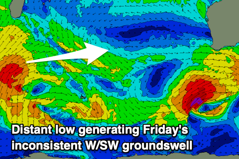
- Inconsistent W/SW groundswell Fri with mod-fresh SE tending stronger S/SE winds (E/SE for periods around Perth and Mandurah), easing Sat with strong E winds
- Small run of surf with dicey winds Sun/Mon onwards
Recap
Plenty of size left across the South West to 6-8ft on Saturday but with poor conditions, choppy and to 2-3ft in Mandurah, cleaner around Perth but still lumpy with 2-3t sets.
Sunday saw cleaner conditions across Perth and Mandurah with less size, dropping back to 1-2ft and 2ft respectively. The South West saw lighter winds and lumpy 4-6ft surf, much better today with a reinforcing S/SW groundswell and offshore winds.
We've got 3-5ft waves in protected spots, with larger sets on the exposed south swell magnets, 1-2ft waves in Mandurah and tiny surf in Perth.

South set wrapping into Yalls this AM
This week and weekend (Sep 21– 26)
Today's S/SW groundswell will ease through the day, leaving smaller surf across all coasts tomorrow under a fresh E/NE tending lighter N/NE winds. Perth and Mandurah will be tiny while the South West magnets are the go for a clean, easing 3-4ft wave.
A low point in swell is then due Wednesday morning with early NE winds across the South West (E/NE further north), shifting NW through the day as a trough approaches. Later in the day SW winds are likely, along with anew, inconsistent SW groundswell.
 This swell source is dicey, as talked about last week, with it originating from an off axis fetch of gale to severe-gale NW winds tracking south-east through our swell window. As a result, only a small and slow 3-4ft wave is due into Wednesday afternoon across the South West, tiny further north.
Thursday looks to offer a touch more size ahead of an inconsistent, long-range W/SW groundswell on Friday. This swell was generated since the end of last week and through the weekend by a distant frontal progression firing up south of Madagascar.
While inconsistent it should offer a bit more size across all locations with 4-6ft sets across the South West, 1-2ft in Mandurah and Perth.
Winds will improve from Thursday but remain out of the S/SE and strengthen across the South West through the day, SE further north. Friday looks cleaner and better with a moderate to fresh SE'ly (E/SE at times in some locations), tending S/SE through the day.
Better, stronger E'ly winds are due Saturday but the inconsistent swell will be fading.
 Looking longer period, unfortunately there's nothing major on the cards at this stage with the westerly storm track being strongest once east of us, under the country. There's no significant long-range swells on the cards, so all in all it's looking fairly slow.
An onshore change is due Sunday as a trough moves through but this doesn't look to be attached to any size.
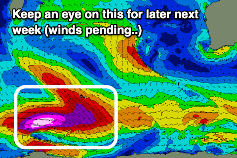
Into next week, a long-range, long-period SW groundswell is on the cards for late week but with possible onshore winds. More on this Wednesday.