Poor tomorrow, improving from Sunday and best early next week

Western Australia Surf Forecast by Craig Brokensha (issued Friday September 17th)
Best Days: Keen surfers Perth early tomorrow, Sunday all regions, Monday all regions, Tuesday morning in the South West
Features of the Forecast (tl;dr)
- Easing surf Sat and Sun with strong W/NW winds tomorrow (lighter N/NE early in Perth and fresh NW in Mandurah)
- Smaller surf Sun AM with fresh S/SE-SE winds in Margs through the AM, lighter E/SE to the north
- Large S/SW groundswell building late Sun, easing Mon with fresh E tending variable winds, easing Tue with stronger E/NE tending light N winds
- Small SW groundswell for Wed PM with NE tending NW winds, strong S/SW Thu
- Inconsistent W/SW groundswell Fri with S/SE winds
Recap
Large, stormy waves across all locations yesterday, biggest into the afternoon across Margs and Mandurah, while this morning we've got lighter winds and lumpy, 3-4ft surf across Mandurah, 3ft in Perth while Margs is still onshore.
This weekend and next week (Sep 18– 24)
The frontal activity and mid-latitude low linked to our large, windy surf the last couple of days is pushing off to the east and we'll see the size continuing to ease into tomorrow, while a weak, mid-latitude front will keep winds onshore in the South West and Mandurah.
A strong W/NW breeze will create poor conditions with 6-8ft of swell, with easing 2-3ft waves further north. Perth should see N/NE winds early but conditions will still be bumpy and not ideal, while Mandurah looks less likely to see these local winds, with a NW'ly persisting.
Sunday is looking much better for a surf as the fronts clears and a high moves in from the west, bringing fresh S/SE-SE winds in the South West through the morning, E/SE in Perth and Mandurah. The afternoon will be bumpy as winds go more S'ly.
Looking at the size, and we'll be in between swells with 4-6ft surf in the South West, 2ft across Mandurah and 1-2ft in Perth. Later in the day a new S/SW groundswell should start to show, with a peak due Monday.
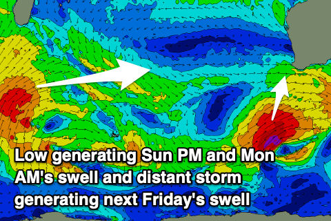 This will be generated by a strengthening low, south-southwest of the state this evening, with a fetch of gale to severe-gale SW winds generated through our southern swell window tomorrow.
Size wise, the South West should see sets pushing to 8ft later Sunday, with Monday seeing easing sets from 6-8ft, with Mandurah easing from 2ft, tiny and to 1-1.5ft in Perth. Conditions will be great Monday with fresh E'ly winds, variable into the afternoon and then fresh E/NE tending N on Tuesday as the swell continues to ease.
There's a tricky, small pulse of mid-period SW swell due Tuesday ahead of a slightly better SW groundswell on Wednesday, generated by a strengthening polar low to our south-west. Off axis fetches of gale to severe-gale NW winds look to generate some fun swell, spreading out radially up towards us, favouring the South West over Perth and Mandurah.
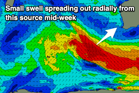 Tuesday's pulse looks minimal and weak, with Wednesday's providing sets to the 4ft range into the afternoon across the magnets (smaller in the morning). Winds will become less favourable and NE tending NW on Wednesday, while a trough brings a strong S/SW change on Thursday.
There's a touch more background swell energy due on Thursday, ahead of a inconsistent W/SW groundswell Friday, generated by the earlier stages of the storm linked to the NW fetch. Today and tomorrow, south of Madagascar a fetch of strong to gale-force W/SW and SW winds will generate this swell, with it due to only offer infrequent 4-6ft sets in the South West on Friday, 1-2ft in Mandurah and Perth. There looks to also be similar amounts of closer-range mid-period energy from a weak polar frontal progression south-west of us mid-week, but we'll review this on Monday. Winds should tend more S/SE on Friday morning (E/SE to the north) ahead of sea breezes, cleaner next Saturday but with easing surf.
Have a great weekend!