More large surf to come, but improving conditions from Friday

Western Australia Surf Forecast by Craig Brokensha (issued Wednesday September 1st)
Best Days: Friday, Saturday, later Sunday in the South West, Monday selected spots, next Thursday
Features of the Forecast (tl;dr)
- Oversized SW swell tomorrow with strong SW winds
- Reinforcing, large, easing S/SW groundswell Fri with light-mod S/SE-S tending S/SW winds in the South West, N/NE-NE tending W/NW in Perth and Mandurah
- Easing S/SW swell Sat with E/NE tending variable onshore winds
- Large SW groundswell building late Sun with fresh E/NE tending lighter N winds, peaking Mon AM with strong NE tending N/NE winds
- Large W/SW groundswell building Wed with SW tending S winds, easing Thu with morning E'ly winds
Recap
Poor conditions and large, onshore surf across the South West yesterday and today, more tempered and to 3ft across the Perth and Mandurah regions.
This week and weekend (Sep 2 – 10)
One more day of onshore winds, then cleaner conditions? It looks so.
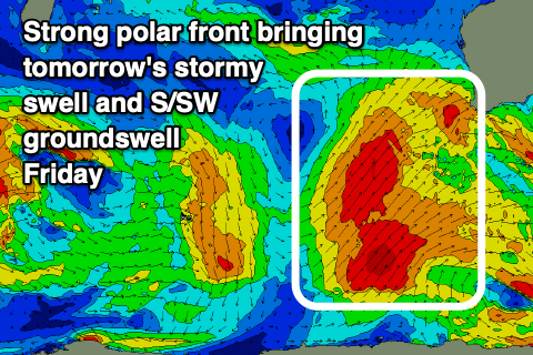
Today's large SW groundswell and onshore winds are linked to a strong frontal progression that projected up and into us through the weekend and earlier this week. Currently, a secondary strong polar frontal progression is pushing up and into us, with it due to produce an additional, oversized mix of stormy swells tomorrow.
 Winds will be strong from the SW in the wake of the front along with 12ft+ surf in the South West, 4ft+ waves in Mandurah and 3-4ft surf across Perth.
A high pressure system should finally start moving in Friday, bringing more favourable S-S/SE winds across the South West, light NE-N/NE in Perth and Mandurah before giving into weak afternoon sea breezes, remaining light to moderate in the South West and from the S/SW.
A final pulse of reinforcing S/SW groundswell is due Friday from the polar frontal progression and fetch of polar S/SW gales during today.
The South West should still be large but easing from the 10ft range on the sets, 3ft in Mandurah and Perth smaller through the day.
Saturday looks smaller again but cleaner in the South West with a light E/NE offshore, similar to the north, tending variable NW in the South West and likely giving into S/SW late sea breezes to the north.
Sunday looks great as well with moderate to fresh E/NE offshore winds and a low point in swell ahead of a large, new long-period SW groundswell arriving late in the day but peaking Monday morning. Winds look light into the afternoon as the swell starts to show, generated by a strong polar low firing up around the Heard Island region tomorrow.
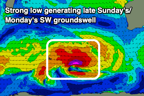 This low will produce a slow moving fetch of mostly severe-gale W/SW winds, reaching storm-force for a short-period on Friday while tracking east.
We may see some mid-period energy arriving midday Sunday across the South West ahead of the stronger, long-period signal with sets due to build to 6ft+ by dark, peaking Monday morning in the 8ft range. Perth and Mandurah aren't likely to see much size before dark Sunday but come in at 2ft and 2-3ft respectively Monday morning.
A strong mid-latitude low moving in from the west will bring stronger NE tending N/NE winds on Monday so aim for the morning surf. Tuesday looks poor with the fading swell and strong N tending W/NW winds as the low pushes in.
The low itself will generate a large W/SW groundswell for mid-late next week, intially with onshore winds Wednesday as it builds, but cleaning up rapidly Thursday with large sets still on offer. More on this in Friday's update.