Slow improvement in conditions, better later week

Western Australia Surf Forecast by Craig Brokensha (issued Monday August 2nd)
Best Days: Margs Thursday and Friday, Perth and Mandurah tomorrow morning, Thursday and Friday
Features of the Forecast (tl;dr)
- Easing mid-period swell tomorrow with NE tending N/NE and then NW winds in Perth and Mandurah, variable tending light W in the South West
- Smaller Wed with E/NE winds, and weak sea breezes
- New SW groundswell Thu with E/NE tending variable winds
- Stronger SW groundswell Fri with strengthening NE tending N/NE winds
- Easing swell Sat with strong W/SW winds
Recap
Well, the hi-res wind forecast for Saturday let me down a little. While it forecast variable winds for the Perth and Mandurah regions, Mandurah was the only place that saw it actually develop, with Perth seeing fresh onshore winds persisting Saturday morning, easing off only temporarily between rain squalls. Even with the variable breeze in Mandurah conditions were still all over the place and not ideal.
Size wise, the swell was still large after easing back from Friday, with yesterday seeing poor, stormy conditions develop across all locations again with a significant frontal system moving through.
Today the large, stormy surf from yesterday has started to ease back in size with lighter winds and cleaner conditions across Perth and Mandurah, dropping from 3ft. The South West was still average and easing from 10-12ft.
This week and weekend (Aug 3 - 8)
Looking at tomorrow, which was expected to see variable winds develop across the South West, and the hi-res modelling is still showing this, but it looks a little touch and go.
What should be pointed out, that with winds blowing onshore right up until dawn and still being onshore out to sea, conditions won't be great in any case, but it's likely we'll see winds go variable through the morning, if not from dawn, in the hour or two after. Weak W'ly winds are then due into the afternoon, so the surf should continue to slowly straighten and clean up.
Perth and Mandurah will see NE winds, shifting N/NE and then variable NW into the afternoon.
Size wise, Perth and Mandurah look to ease from a small 2ft, with Margs dropping from 5-6ft on the sets.
 Wednesday looks cleaner wth a light E/NE offshore in the South West and further north but with a low point in swell. Margs looks the pick with sets to 3ft+, tiny in Perth and Mandurah and to 1-1.5ft. Sea breezes will be relatively weak and the afternoon workable.
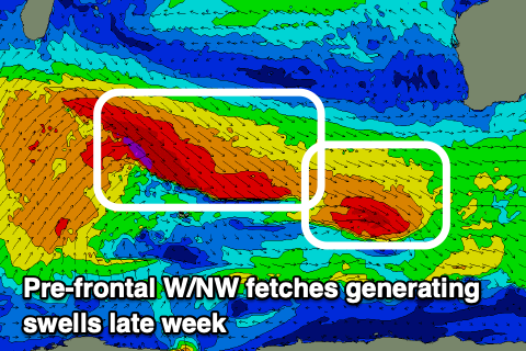
Into Thursday and Friday new pulses of SW groundswell are due, generated by an elongated fetch of pre-frontal W/NW gales moving through our swell window, north and north-east of the Heard Island regions.
The fetch will actually split in two with the leading fetch generating an initial pulse of SW groundswell for Thursday, while the trailing, secondary and stronger fetch should produce a larger pulse for Friday.
The first pulse for Thursday should come in around 5-6ft across the South West, 2ft in Mandurah and 1-2ft in Perth, while the second looks bigger and better, coming in at 6-8ft, 2ft+ and 2ft respectively Friday.
Conditions will be best in the mornings, with an E/NE offshore on Thursday ahead of weak, variable sea breezes, strengthening from the NE on Friday and tending N/NE into the afternoon.
 A trough will unfortunately bring an onshore change on Saturday as the swell eases, with N'ly winds kicking in again on Sunday.
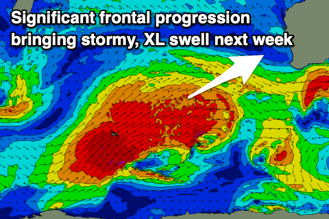
Swell wise, some moderate, mid-period surf is on the cards, but longer term we've got a much more significant polar frontal progression on the cards for the weekend.
This progression looks t generate an XL W/SW groundswell event but with all the wind as it pushes up and across us, early next week. It looks to be a case of once the wind dies off and goes offshore, most of the swell will be gone, but check over the coming updates for more on this.