Get in tomorrow, then aim for mid-late next week

Western Australia Surf Forecast by Craig Brokensha (issued Wednesday June 23rd)
Best Days: Tomorrow in the South West, possibly dawn Friday in the South West, Perth and Mandurah next Wednesday
Features of the Forecast (tl;dr)
- Inconsistent mix of new SW groundswells Thu, peaking into the PM with light to moderate E/NE tending variable N winds
- Easing surf Fri with a moderate NW breeze (possibly N/NE early in the South West)
- Building W'ly groundswell later Sun but peaking Mon with fresh W tending W/NW winds
- Larger mid-period swell building Tue with strong, easing W/SW winds
- Large SW groundswell Wed with variable winds in Perth and Mandurah, W/NW tending NW in the South West
Recap
Clean, peaky easing surf out of the S/SW yesterday to 2ft+ across Mandurah and 2ft in Perth, choppy and poor across the South West. Today the swell is still 1-2ft around Perth and Mandurah with OK winds, a little better in the South West but with no size.
This week and weekend (Jun 22 - 27)
Make the most of tomorrow, that's the take home message from today's forecast.
We should see a mix of long-range and closer-range SW groundswell filling in, peaking through the afternoon. Size wise Mandurah and Perth aren't expected to see too much in the way of size with Margs performing the best.
The long-range energy was generated by a distant storm, south-east of South Africa, and the closer-range energy from a deepening polar low east of the Heard Island region earlier this week.
 Size wise, Margs should see 4-5ft+ sets (peaking after lunch), with building sets to 1-1.5ft across Mandurah and Perth.
Conditions will be cleanest in the morning with a light to moderate E/NE breeze, shifting N/NE and then variable N into the afternoon.
Come Friday the swell will be on the ease along with NW winds in the South West (possibly light N/NE at dawn) and moderate N/NE-NE early across Perth and Mandurah.
Moving into the weekend there's still no decent surf due and strengthening N/NE winds will create average conditions Saturday, stronger and near gale-force into Sunday, shifting NW through the afternoon.
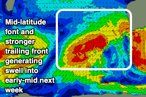
This persistent run of winds out of the north will be due to a slow moving mid-latitude low pushing in slowly from the west, squeezing a high across the country.
The remnants of the low will finally move in Sunday evening bringing fresh onshore W tending W/NW winds on Monday as a stronger polar front fires up towards us.
Coming back to the mid-latitude low though and we'll see this generate a moderate-large W'ly groundswell for later Sunday and Monday, with a fetch of severe-gale W/SW winds projected through our western swell window, south-east of Madagascar over the coming days.
Margs looks to come in around 8ft, with 3ft surf further north but with that onshore wind.
The polar front will project gale-force W/SW winds up and into us, weakening while moving through on Tuesday and this will see a mid-period swell building Tuesday ahead of the groundswell proper on Wednesday.
Tuesday will remain poor with strong, though easing W/SW winds as the mid-period energy strengthens, with Wednesday coming in around 10-12ft in the South West, 4ft across Mandurah and 3-4ft in Perth.
Winds look to abate quickly into Wednesday as a high slides in ahead of another mid-latitude front, but Margs looks to still see W/NW tending NW winds, more variable and E/NE to the north.
A reinforcing moderate-large W/SW swell may be generated by this storm, arriving later week as winds hopefully improve across all locations as a stronger, clearing high drifts in. More on this in the coming updates though.
Comments
Yummy!
Though the waves are more this size..