Large swells this week, with one standout day

Western Australia Surf Forecast by Craig Brokensha (issued Monday June 14th)
Best Days: Perth and Mandurah tomorrow morning, similar Wednesday morning, Thursday, Friday selected spots
Features of the Forecast (tl;dr)
- Easing large SW swell tomorrow with strong SW tending S/SW winds (variable E/NE tending N Perth and Mandurah in the AM before going S/SW)
- Smaller Wed with light S winds (E/NE Perth and Mandurah tending S)
- Large, long-period SW groundswell arriving late Wed, peaking Thu with E/NE tending vairable NE winds, easing Fri with strengthening N/NE tending N winds
- Building W/SW swell Sat PM, peaking Sun with strong NW tending W and then SW winds
Recap
Clean conditions with inconsistent, smaller surf compared to Friday, best across the South West magnets and small to tiny to the north.
Sunday was poor and bumpy in the South West with small waves persisting to the north with lighter winds. Today a strong cold front has filled in with a mix of different swells but with fresh to strong onshore winds, limiting surfing options.
This week and weekend (Jun 15 - 20)
The vigorous cold front responsible for today's large, onshore surf will be slow moving, resulting in poor, strong SW winds persisting across the South West tomorrow morning, tending S/SW late in the day.
Perth and Mandurah should see more favourable, variable E/NE winds through the morning, shifting more N'th ahead of the onshore winds into the afternoon. Size wise we'll see the mid-period swell and windswell generated by today's front easing back from 10ft+ across the South West, 4ft in Mandurah and 3-4ft in Perth.
Wednesday looks a bit better but far from ideal with lingering S'ly winds across the South West, E/NE further north and with a further drop in size. The South West should ease from 5-6ft with 2ft waves to the north.
We then look at our large, long-period SW groundswell due into Thursday and window of favourable winds.
This swell has started to be generated by a strong polar low that's developed in the Heard Island region. It's producing storm-force W/SW winds and will continue to do so until weakening south-southwest of us Wednesday morning.
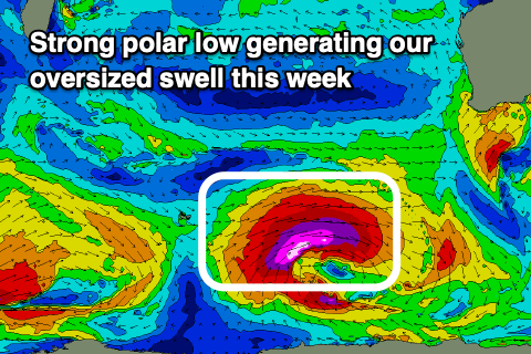 The persistent storm-force fetch will generate a large, long-period and powerful SW groundswell that should start to show late Wednesday but fill in proper Thursday, peaking through the morning to 12-15ft across the South West, 3-4ft in Mandurah and 3ft across Perth.
Winds look great, swinging light to moderate E/NE for Thursday morning and then variable NE into the afternoon. This window will be short-lived though with Friday seeing strengthening N/NE tending N winds as a mid-latitude low pushes in from the west.
This will be with easing sets from 6ft+ in the South West, 2-3ft further north.
The mid-latitude low will generate a fresh pulse of W/SW groundswell for Sunday but winds look poor with stronger N-N/NW winds ahead of the front Saturday, then shifting W to SW through Sunday. Size wise the South West looks to be around 8-10ft, 3ft+ in Mandurah and 2-3ft across Perth.
Cleaner conditions should be seen into early next week as the swell eases.
Longer term it looks like we're set for a run of large, stormy onshore surf out of the west as mid-latitude systems push up and into us. More on this Wednesday.