Windy week developing, much better on the weekend

Western Australia Surf Forecast by Craig Brokensha (issued Monday April 5th)
Best Days: Keen surfers South West magnets tomorrow morning, Saturday afternoon in the South West, Sunday
Features of the Forecast (tl;dr)
- Small, fading surf tomorrow with a light E/NE tending W/SW breeze
- Small, mid-period SW swell building late Wed, peaking Thu with strong S/SE winds, easing Fri with strong S/SE-SE winds
- Large, S/SW groundswell building Sat PM, easing Sun with strong, easing E winds Sat, fresh E/NE tending variable Sun
Recap
Clean, small waves to start off the weekend ahead of a new swell Saturday afternoon which held into yesterday to a clean 4-5ft across the South West. Perth and Mandurah didn't see much in the way of surf (under expectations in Mandurah) with tiny waves for the most part.
Today the swell has eased with shifting winds, turning onshore everywhere this afternoon.
This week and weekend (Apr 6 - 11)
We'll see winds swing back offshore across the state tomorrow morning but there'll be no decent size with easing 2-3ft sets across the South West, tiny to the north. A light E/NE breeze will give into relatively weak afternoon sea breezes so try the South West magnets.
Now, the tricky outlook with a high pressure ridge combining with tropical activity will see winds strengthen along our state towards the end of the week. Variable winds on Wednesday due to swing W/SW, strengthen overnight and then swing strong S/SE on Thursday as Tropical Cyclone Seroja drifts south-west over the coming days, then slowly south as Seroja squeezes a strong high to our south-west.
Winds look to remain strong Friday out of the S/SE-SE, shifting more E/SE finally on Saturday (variable into the afternoon) and then E/NE on Sunday. This will be as the strong high moves ever so slowly east under us, but what about the swell?
We'll be looking at a moderate sized, mid-period swell for later Wednesday but more so Thursday, generated by a relatively weak frontal system over the weekend and today.
Size wise, don't expect much over 4ft across the South West, tiny and windswelly to the north with the strong winds with a southerly bias.
The weekend looks much better regarding swell with a 'bombing' low due to develop south-west of us, late in our swell window Thursday.
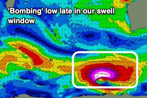 A 'bombing' low is one that drops 24hPa or more within 24 hours and this will drop about 34hPa from Wednesday afternoon to Thursday afternoon.
This will see a fetch of storm-hurricane force W'ly winds firing up along the polar shelf, projecting east through out southern swell window and then onwards to Tasmania.
We'll still see a good pulse of long-period, S/SW groundswell on the weekend, arriving Saturday afternoon and building to 6-8ft by late afternoon, peaking overnight, with the odd bigger one likely breaking in the darkness.
The swell should show on dark further north but likely peak until Sunday with small, inconsistent 2ft sets across Mandurah, 1-2ft in Perth owing to the south direction. Margs should ease from 6-8ft. We'll see good conditions under those winds discussed above.
Following this swell, smaller, mid-period energy is on the cards, but more on this in the coming updates.
Comments
I think I heard Mr BOM NW WA say Fujiwara!!
RC, You might get something up your way later in the week, amongst the crowds
Yeah! the weather girl on ABC just showed a neat cyclone tracking diagram and mentioned the Fujiwara effect!
“a phenomenon that occurs when two nearby cyclonic vortices move around each other and close the distance between the circulations of their corresponding low-pressure areas.”
The tracking showed it going all the way down the coast past Shark Bay and down towards Gero. Craig, could we be in store for another rare North swell in Perth & the south west like a few years back?
Yeah it looks like they do the dance! Will be talking to Tyne later in the week, and at this stage no, all the action is north of Perth.