Fading energy, back up next week

Western Australia Surf Forecast by Craig Brokensha (issued Monday March 22nd)
Best Days: Desperate surfers tomorrow across all locations, Wednesday morning across the South West swell magnets
Features of the Forecast (tl;dr)
- Easing W/SW swell with some new mid-period S swell tomorrow with fresh and gusty S/SE-SE winds in the morning, fading Wed with E/SE-E winds
- Small, weak SW swell for Fri with light SE winds
- Increasing energy through next week
Recap
Good, clean 3-4ft waves Saturday across the South West, easing through the day, while Mandurah and Perth held around 1-2ft, better than expected.
Our new W/SW groundswell for Sunday filled in nicely, building from a clean 4-6ft in the South West, 2ft in Mandurah and 1-2ft in Perth. The swell peaked through the day but sea breezes were in by midday.
Today we've seen a trough bring strong S'ly winds to the South West along with the easing swell, bumpy though workable to the north and coming in around 2ft+.
This week and weekend (Mar 23 - 28)
As touched on in last week's updates, we'll see the surf easing in size over the coming days, in the wake of yesterday's W/SW groundswell and winds will take their time to swing back offshore, so by the time the magnets clean up, there won't be much left in the tank.
Fresh and gusty S/SE-SE winds are due tomorrow as the swell eases back from 4ft in the South West, tiny and to 1-1.5ft or so to the north. A weak low forming south of us today will direct strong S'ly winds towards us, adding a small, weak S'ly swell to the mix tomorrow.
Smaller surf is due Wednesday and only likely 2-3ft out of the S/SW across the South West magnets with an E/SE tending E'ly breeze.
The swell will fade further Thursday with a favourable morning offshore out of the E while a slight lift in mid-period SW energy is due Friday to 2-3ft in the South West with a light, morning SE breeze.
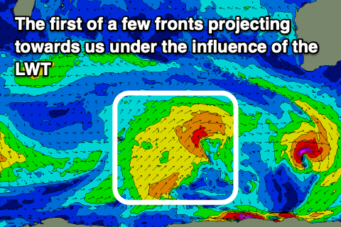 Moving into the weekend there's no new swell due, but we should start to see an increase in energy through next week as a strengthening node of the Long Wave Trough moves slowly in from the west.
This node isn't overly strong and the frontal activity will be fairly subdued as a result but we should still see some new mid-period swell developing through early next week, possibly followed by groundswell later week.
Due to the frontal activity moving nearer to us, winds look to deteriorate and blow from the south-western quadrant, but more on this in the coming updates.