Good surf options from Sunday

Western Australia Surf Forecast by Craig Brokensha (issued Friday March 5th)
Best Days: Desperate surfers Perth and Mandurah tomorrow AM for inconsistent W/NW swell, Sunday and Monday all locations, Tuesday morning in the South West
Features of the Forecast (tl;dr)
- Small NW swell from TC Mariana Sat and Sun
- Good SW groundswell building Sat, peaking late in the day across the South West and Sun AM further north, with a secondary stronger swell Sun, easing slowly Mon
- S/SE winds Sat AM, SE winds Sun AM, SE tending E/SE Mon AM and E/SE tending E/NE Tue AM
Recap
Small to tiny surf with a bit of weather passing through early yesterday, bumpy and onshore today with a very slight lift in energy.
This weekend and next week (Mar 6 - 12)
With the low point in swell out of the way we look to our good pulses of groundswell due on the weekend.
Back to back increases are due, the first, least consistent and smallest is expected to build through tomorrow, with a secondary slightly stronger pulse Sunday.
Tomorrow's was generated by a broad fetch of W/SW gales projecting north of the Heard Island region through this week, with it due to build strongly tomorrow afternoon, reaching 6ft+ across the South West, only small and to 1-2ft all day out of the W/NW to the north from Tropical Cyclone Marian.
Sunday morning should see similar waves across the South West, with better size in Mandurah to 2-3ft and 2ft+ across Perth.
The secondary swell looks to arrive during Sunday morning now, generated by a secondary, strong low that's currently south-west of us, producing a great fetch of severe-gale W/SW winds.
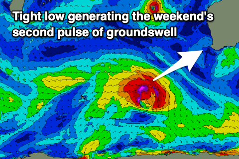 This low will track south-east and away from us, with the swell due to arrive Sunday morning, kicking the surf to a larger 8ft to possibly 10ft in the South West through the afternoon with Mandurah seeing more consistent 3ft surf, 2-3ft in Perth.
The swells should then ease Monday, dropping from 6ft+, 2-3ft and 2ft+ respectively.
Looking at the local winds and we'll see a moderate S/SE breeze tomorrow morning in the South West (light offshore to the north) ahead of sea breezes, then moderate to fresh SE breezes Sunday morning, with sea breezes in Perth and Mandurah, stronger S/SE across the South West.
Monday should see strong SE winds easing and tending E/SE late morning, with E/SE breezes to the north, with mid-late afternoon sea breezes on the cards.
Tuesday will be best in the South West as the swell continues to fade along with fresh E/SE tending E/NE winds.
Our next increase in swell looks to arrive late week, though it won't offer much in the way of size. The mid-period S/SW swell will be generated by relatively weak polar frontal activity, but we'll have a closer look at this Monday.
In the meantime make the most of the coming surf. Have a great weekend!