Windy, new swell to end the week

Western Australia Surf Forecast by Craig Brokensha (issued Wednesday January 13th)
Best Days: Keen surfers Friday, beaches Saturday morning, keen surfers Tuesday and Wednesday mornings
Features of the Forecast (tl;dr)
- Moderate-large S/SW groundswell for tomorrow AM, easing with strong SE-E/SE winds, S/SE into the afternoon
- Small, inconsistent SW groundswell building Mon PM with N winds, easing Tue AM with NE winds
Recap
A good kick in swell yesterday across the South West with 5-6ft sets on the swell magnets though winds made conditions bumpy, quickly deteriorating to choppy. Mandurah and Perth saw a bit more size, though early winds also quickly strengthened and swung, creating poor conditions.
Today the swell has eased with bumpy 3-4ft waves in the South West, cleaner to the north and easing from 1-1.5ft.
This week and weekend (Jan 14 - 17)
Into this afternoon we should see our new S/SW groundswell building across the South West, peaking tomorrow morning in the South West with sets to 6ft+ on the swell magnets, 2ft+ in Mandurah and 2ft on the sets across Perth.
The swell was generated earlier this week by a healthy polar low forming around and pushing just east of the Heard Island region.
Winds are looking better than the last two days with a strong SE-E/SE breeze across all locations, S/SE into the afternoon across the South West, with sea breezes likely to be held off for Perth and Mandurah as well.
The swell will ease steadily through the day, smaller Friday with leftover 3ft+ sets on the swell magnets, tiny to the north. Winds are looking a bit better, strong E/SE through the morning, holding all day in Perth and Mandurah but stronger S/SE across the South West.
Conditions will remain clean into Saturday but the swell will be smaller again and fading from 2ft to possibly 3ft in the South West, flat to the north, small again Sunday morning. A small background swell may keep 3ft sets hitting the South West Sunday, but keep your expectations low.
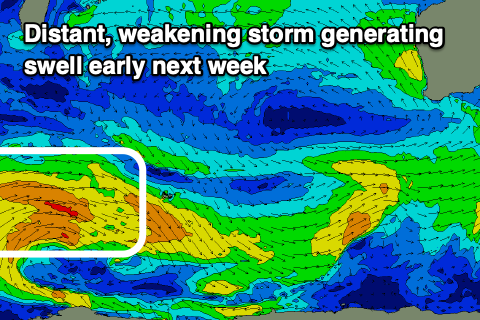 Unfortunately there's nothing significant on the cards for the long-term outlook, with just a slight increase in small, inconsistent mid-period SW swell through Monday afternoon, easing Tuesday.
The source of this swell is a distant fetch of broad, though relatively weak W'ly winds west of the Heard Island region, with the polar low weakening today. Size wise nothing over 4ft is likely across the South West late Monday and Tuesday morning, tiny to the north. Winds look favourable Tuesday morning and light from the NE, but we'll review this Friday.
Longer term there's still nothing major on the charts, so try and make the most of tomorrow's swell.