Slim window for the weekend, windy next week but with a couple of swells

Western Australia Surf Forecast by Craig Brokensha (issued Friday January 8th)
Best Days: Saturday morning in the South West (lower expectations), Perth and Mandurah tomorrow morning, Tuesday morning in the South West, Thursday morning
Features of the Forecast (tl;dr)
- New inconsistent SW groundswell Sat with variable winds in the morning (likely light onshore in the South West)
- Strong S/SE-SE winds next week with mid-period S/SW swell Tue, better groundswell Thu
Recap
Wednesday's large S/SW groundswell eased back through yesterday with fun, clean 4-5ft waves across Margs through the morning, 1-2ft in Mandurah and tiny in Perth. This morning is smaller again but clean before winds go northerly ahead of sea breezes.
This weekend and next week (Jan 9 - 15)
We should see the swell lift into tomorrow with the arrival of a new, inconsistent SW groundswell that was generated by a more distant, weaker low (compared to the one linked to Wednesday's swell).
The swell should show later today in the South West but peak tomorrow morning, providing infrequent 5-6ft sets across the South West magnets, 2ft in Mandurah and 2ft on the sets across Perth.
The early will be the go though, the timing of a weak S'ly change for the South West now looks to be right around day break. Pre-dawn, light winds should create clean conditions, with light S tending SW winds moving in around dawn, though workable freshening from late morning. Perth and Mandurah should offer light winds and clean conditions all morning.
 Sunday looks average with the SW groundswell easing under fresh to strong S'ly tending S/SW winds.
Moving into Monday and winds should swing SE across the South West, more E/SE further north as the swell drops further in size. The South West will be a windy 4ft on the magnets and not great, tiny to the north.
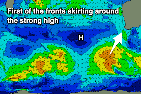
Our new mid-period S/SW swell for Tuesday is on track, with a frontal system firing up around the Heard Island region this evening, generating strong to sub-gale force W/SW winds through our swell window on the weekend.
The swell won't offer any major size or power, but 4-5ft+ sets are due in the South West Tuesday, 1-2ft in Mandurah and tiny across Perth.
 With a strong high sitting to our west, squeezed by polar fronts on its south-eastern flank, winds will remain strong and from the S/SE on Tuesday, limiting surfing options, back to the SE on Wednesday morning though still gusty with a drop in swell.
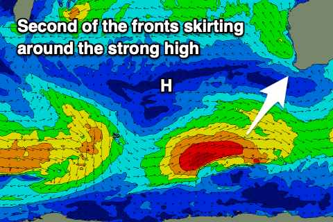
We've got a slightly stronger S/SW groundswell due late Wednesday but more so Thursday from the second of these fronts skirting around the high, with a good fetch of gales projected through our swell window. Size wise we're looking at 6ft+ surf in the South West, 2ft+ in Mandurah and 1-2ft across Perth with strong morning SE winds, but more on this Monday. Have a great weekend!