Fun windows of waves before slowing down

Western Australia Surf Forecast by Craig Brokensha (issued Wednesday 25th November)
Best Days: Tomorrow morning (early in the South West for the cleanest conditions), Sunday morning in the South West, Tuesday and Wednesday mornings
Recap
Our large SW groundswell finally kicked later into the afternoon Wednesday and with a peak overnight, the swell eased back from the 6-8ft range yesterday across the South West, 2-3ft in Mandurah and Perth. Conditions were cleanest early with deteriorating waves north of Margs late morning, with bumpy conditions from mid-late morning in the South West.
Today the surf is poor in the South West with the swell easing further along with a fresh SW'ly, fun and to 1-2ft around Perth and Mandurah.
This weekend and next week (Nov 28 – Dec 4)
With the swell dropping back into today, we look at a new pulse of inconsistent W/SW groundswell due to fill in tomorrow across the state.
This was generated by a strong but distant polar low during this week that developed west of Heard Island before projecting north-east towards us while weakening.
The swell will be infrequent but should build during the day to 5-6ft on the exposed reefs across the South West, 2ft on the sets in Mandurah and 1-2ft across Perth.
 Winds look favourable and light E/SE across the South West at dawn with S/SE winds further north, swinging back S/SE mid-morning around Margs ahead of sea breezes.
Sunday will be best in the South West as the swell eases along with a light offshore E/SE breeze, S-S/SE further north and tiny.
Moving into early next week our mix of mid-period S/SW swell and S/SW groundswell for Monday/Tuesday are still on track but so are the onshore winds as it kicks.
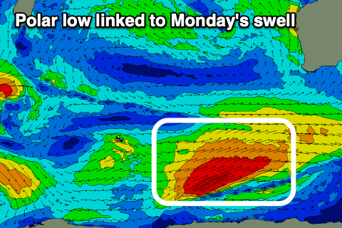
A strong polar low has formed east of Heard Island and a slow moving fetch of gale to severe-gale W/SW winds are being generated in our southern swell window.
The low will weaken slowly this evening while moving east and stretching out, but a front spawning of the lows tail will project up and into us, generating a fetch of strong S/SW winds.
We'll see the S/SW groundswell peak Monday, with the mid-period S/SW swell in the mix, coming in around 6-8ft across the South West, building to 3ft in Mandurah and 2-3ft across Perth into the afternoon mostly from the mid-period source.
Conditions will be poor with strong SW tending S/SW winds, with Tuesday looking much better as winds swing back to the E/SE across Perth and Mandurah, E/SE-SE in Margs.
The mix of swells will be on the ease, dropping from 6ft+ across Margs and 2-3ft to the north, smaller Wednesday as winds play out similarly, though likely more E/SE down around Margs.
Unfortunately as touched on in Wednesday's notes, the longer term outlook is slow with weak, mid-latitude storms not expected to offer much in the way of surf or swell for the rest of the week/next weekend.
Winds look funky and out of the south in general as the mid-latitude systems weaken on approach and get pushed out by a growing high to our west. More on this Monday though. Have a great weekend!