Fading surf, poor weekend and a window next week

Western Australia Surf Forecast by Craig Brokensha (issued Wednesday 16th September)
Best Days: South West swell magnets tomorrow and early Friday, next Wednesday
Recap
Large, clean surf around the 10ft range across the South West yesterday morning before sea breezes kicked in, 3ft in Mandurah and 2-3ft across Perth.
Winds have shifted a little less favourable today across Perth and Mandurah along with a drop in swell back to 2-3ft, 4-6ft across Margs but onshore.
This week and next (Sep 17 - 25)
Today's swing in winds is associated with a deepening trough pushing up from the south and we'll see this quickly slide east as a high moves in below us.
This will swing winds around to the E/SE-E tomorrow morning, fresh to strong early but easing and then becoming variable into the afternoon.
Size wise the surf will become smaller with easing 3-4ft sets in the South West, tiny further north and to 1-1.5ft.
Friday looks even smaller and only surfable in the South West and on the magnets as the swell bottoms out and winds swing from a fresh E/NE'ly around to the N/NE and then N/NW.
Unfortunately a new S/SW groundswell due for Saturday will be spoilt by a trough turning into a mid-latitude low through the weekend, with Friday afternoon's northerlies shifting to the W/SW just after dawn Saturday and becoming strong.
This will create poor conditions but some stormy mid-period swell is due to build, becoming large into Sunday though with strong persistent SW winds.
The large swell will be generated by a slow moving fetch of strong W/SW tending SW and then S/SW winds being projected into us, with the size likely to reach a low quality 8ft+ or so, 3ft+ in Mandurah and 2-3ft across Perth.
The low should move slowly east Monday as the mid-period swell eases but winds look to remain onshore from the SW, possibly even lingering Tuesday.
It looks like we'll see winds swing back offshore Wednesday along with a good new W/SW groundswell.
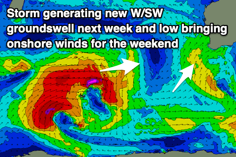 The source is a slow moving and broad low pushing east through the Southern Ocean this weekend, with a great fetch of gale to severe-gale W/SW winds projected towards us.
The swell should build Wednesday and reach 8ft+ across the South West Sunday, 2-3ft in Mandurah and 2ft+ across Perth with an E tending NE breeze, while a mid-latitude low moving in Thursday will bring onshore winds back into the fold.
More on this Friday though.