Good run of conditions and swell from Sunday

Western Australia Surf Forecast by Craig Brokensha (issued Friday 11th September)
Best Days: Perth and Mandurah tomorrow morning, Sunday, Monday, Tuesday morning
Recap
Poor conditions across all locations yesterday with a building onshore swell, while today is completely opposite with great surf across Perth and Mandurah, improving in the South West. This is with a new large, long-period W/SW groundswell.
The swell is due to start easing this afternoon with sea breezes.
This weekend and next week (Sep 12 - 18)
We’ll see today’s swell easing across all locations tomorrow and the variable wind for the South West is now looking a little 50/50. It’s probably on the less likely side, but fortunately the following days are looking much cleaner and better.
Perth and Mandurah should see good E/SE offshores as the swell eases from 2ft+ across the former, and 2-3ft on the latter. Margs looks to ease back from 6-8ft.
Our new building SW groundswell event through Sunday is on track, with a great elongated fetch of severe-gale W/SW winds being drawn out just west of Heard Island.
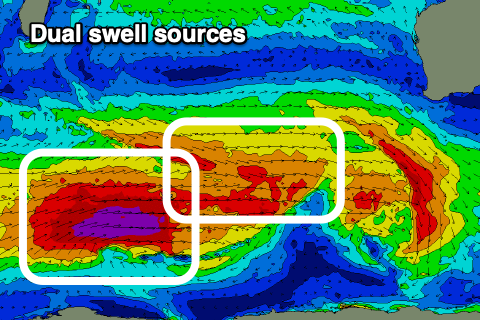 We’ll see this fetch weaken as pre-frontal W/NW gales spread out ahead of it, generating an initial large SW groundswell for Sunday, building through the day. The less consistent and slightly longer-period groundswell from the fetch today is then due to fill in Monday afternoon/Tuesday.
Size wise, the building swell Sunday should kick to to 8ft on the sets across the South West, 2-3ft in Mandurah and 2ft+ across Perth. Similar sized surf is due Monday morning with the stronger pulse later in the day and Tuesday seeing the odd bigger one to 8-10ft in the South West, more so 3ft across Mandurah but inconsistent and 2ft to occasionally 3ft in Perth.
Winds should swing offshore Sunday as a high slides in from the west, E/SE across all locations ahead of S/SW sea breezes and then fresher E-E/NE on Monday morning. Tueday may see winds revert back to the SE-S/SE but we’ll review this Monday.
Looking at the rest of the week and a couple of funky troughs moving in from the west look to spoil conditions Wednesday through Friday as the swell drops away.
There’s nothing too significant at this stage with meandering lows through the southern Indian Ocean through next week, but we’ll look at this in more detail Monday. Have a great weekend!