Large damaging and windy surf on the way

Western Australia Surf Forecast by Craig Brokensha (issued Monday 22nd June)
Best Days: Thursday morning Perth and Mandurah
Recap
Friday's swell eased off rapidly into Saturday leaving 4-5ft waves across the South West with clean conditions, clean again Sunday morning ahead of a new W/SW groundswell. Mandurah was a clean 2-3ft Saturday, back to 2ft yesterday morning ahead of the new increase in long-period W/SW groundswell. Perth was 2ft Saturday but tiny yesterday morning ahead of the new swell.
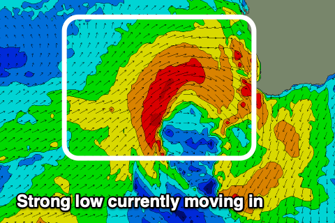
Today the size has held after yesterday's spike but conditions are deteriorating with strengthening N'ly winds ahead of a strong mid-latitude low. This low will continue to push towards us this afternoon ahead of a gale-force W'ly change this evening.
This week and weekend (Jun 23 – 28)
The current forecast is for more oversized onshore and stormy swell which will continue to impact those locations already suffering severe erosion.
The strong mid-latitude low that's on the way is producing a fetch of strong to gale-force W'ly winds through our western swell window and will dip south-east across us while maintaining strength this evening. Into tomorrow the tail of the low will continue to generate a strong fetch of W/SW winds through our south-western swell window, persisting through Wednesday.
 We'll see a stormy XL W/SW swell develop for tomorrow and then only ease slowly while tending more SW in direction through Wednesday and Thursday.
Size wise the South West looks to come in around 10-12ft+ through the day, possibly a touch undersized early, 5-6ft across Mandurah and 4-5ft+ in Perth. Conditions will be very poor though with a strong W tending W/SW-SW breeze.
Wednesday will still be large but with a touch less wind, fresh and gusty out of the W/SW with easing sets from 10-12ft, 3-5ft in Mandurah and 3-4ft across Perth.
Come Thursday Perth and Mandurah should offer a morning NE breeze and smaller dropping swell from 2-3ft and 3ft respectively. The South West will remain onshore out of the N, tending N/NW through the day.
A weak mid-latitude front pushing up and towards us will bring the northerly winds Thursday but no significant increase in swell for Friday. Instead NW tending W/SW winds will create poor surf again.
A new long-range SW groundswell is due to arrive later Saturday but peak Sunday, mixed in with some localised W/SW swell from a broad polar front that's currently just west of the Heard Island region. Wind speeds aren't overly strong from the initial stages of the low, and the remnants will develop into a mid-latitude system west-southwest of us this weekend.
Unfortunately the front will bring onshore W/NW winds on Saturday, stronger NW Sunday as an even stronger mid-latitude front approaches us. This will be as the swells fill in and peak, coming in at a stormy 8ft+ or so in the South West, 3ft+ across Mandurah and 2-3ft in Perth.
Now this stronger and what now looks to be severe low will develop under the influence of a strong and slow moving node of the Long Wave Trough. We'll see a fetch of gale to severe-gale W/SW winds projected into us Sunday evening and Monday generating an XXL stormy swell again for early next week with a possible weaker follow up front Tuesday. This again doesn't fare well for those metro areas currently damaged by erosion, but more on this Wednesday.