Clean and fading surf, lots of activity from the weekend

Western Australia Surf Forecast by Craig Brokensha (issued Wednesday 20th May)
Best Days: Tomorrow in the South West, similar Friday for keen surfers, Saturday afternoon selected spots
Recap
Great waves across all locations yesterday with a large easing SW groundswell from 6-8ft in the South West, 3ft in Mandurah and 2-3ft across Perth with morning offshore winds and workable afternoon breezes.
Today we've got smaller surf across all locations, clean and fun to 2ft in Mandurah and 1-2ft Perth, OK early in the South West but now not as favourable.
This week and weekend (May 21 - 24)
The surf will continue to ease into tomorrow and Friday, bottoming out Saturday morning across the state ahead of a run of large and onshore building surf into Sunday and next week.
 We'll be looking at slower 3-4ft sets across the South West magnets tomorrow, smaller Friday with tiny waves in Perth and Mandurah. E/NE tending variable winds are due tomorrow, so make the most of it, with moderate E/NE tending NE winds Friday but with less size.
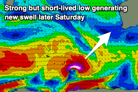
As we move into Saturday strengthening N/NE winds will create average conditions, but there is a new swell due into the afternoon that's worth keeping an eye. This long-period and inconsistent SW groundswell will be generated by a strong but south-east tracking and short-lived polar low firing up east of Heard Island today.
A fetch of severe-gale to storm-force W/NW winds should produce a good kick in size to 5-6ft across Margs late in the day with those N/NE winds.
Come Sunday, stronger N winds are on the cards ahead of a change, but the models still diverge on the timing of this. Either way we'll see Saturday's swell easing from 5-6ft or so ahead of building windswell.
The divergence hangs into early next week with EC showing offshore winds Monday morning before a strong change moves through, while GFS has these offshore winds for Tuesday.
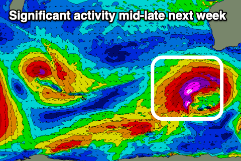 Either way we'll be looking at a large new inconsistent W/SW groundswell building Monday from a great fetch of severe-gale W/SW winds pushing through the southern Indian Ocean. Sets to 8-10ft are due to build across the South West, 3ft+ in Mandurah and 3ft in Perth.
Check back Friday for the local winds meeting this swell, but following it we'll see a strong node of the Long Wave Trough steering a series of strengthening mid-latitude to polar storms up and into us from Wednesday.
At this stage we're looking at XXL onshore surf later week, but more on this Friday.