Here comes the wind and swell

Western Australia Surf Forecast by Craig Brokensha (issued Friday 17th April)
Best Days: Early tomorrow, Perth possibly Monday morning, Perth and Mandurah possibly Thursday morning
Recap
A peak in SW groundswell yesterday morning to 6-8ft across the South West, 2-3ft in Mandurah and 2ft+ across Perth with offshore winds and improving conditions before sea breezes kicked in.
Today the swell is still a great size with a reinforcing pulse of S/SW groundswell keeping the South West around 6ft+ with great offshore winds, 2-3ft in Mandurah and 2ft Perth.
This weekend and next week (Apr 18 - 24)
Make the most of the current conditions as besides tomorrow morning, conditions will be poor and onshore for most of the coming period in the South West.
We'll see the current swell continuing to ease into tomorrow, back from 4ft+ in the South West, 1-2ft in Mandurah and 1-1.5ft across Perth. Winds will be less favourable but OK and light S/SE-SE before shifting SW through the morning.
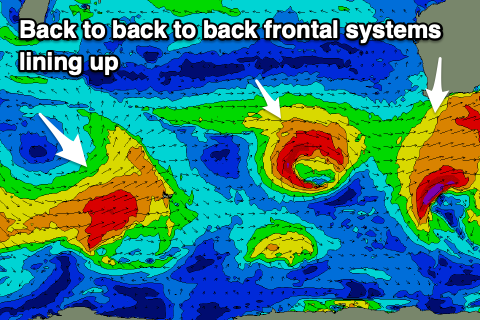
As touched on the last couple of updates, we're expected to see a run of onshore winds and building swells as a series of strong mid-latitude fronts push up and into us under the influence of a broad and strong node of the Long Wave Trough stalling just west of us.
 We've had upgrades and then downgrades but now it's upgraded again.
The first of these fronts will move in on the weekend, bringing strong onshore W/SW winds and a building swell Sunday, peaking Monday with strong W/NW winds as another system pushes up and towards us.
Unfortunately the morning offshores across Mandurah aren't expected any more Monday, but Perth should see early variable winds and lumpy decent sized waves.
The swell for Monday should peak around 6-8ft in the South West, 3ft in Mandurah and 2ft to occasionally 3ft in Perth.
The secondary system looks a little stronger and with this we'll see winds remain onshore across all locations into Tuesday out fo the W tending NW as the swell kicks back to 8-10ft in the South West, 3-4ft in Mandurah and 3ft across Perth.
A third system is expected to then project towards us through the week, bringing another large pulse of W/SW swell for Thursday but with persistent W'ly winds across the South West. Early variable winds are a possibility in Perth and Mandurah with sets to 3ft.
Longer term a much broader and stronger polar low is forecast to fire up later week, generating an even larger long-period SW groundswell for next weekend, but we'll keep a close eye on this. More Monday. Have a great weekend!
Comments
The low in the north looks pretty paltry but I got the charts, the slide rule and abacus out and reckon I'll get a few tubes. At a certain break.