A couple of fun days ahead of a run of onshore winds and large surf

Western Australia Surf Forecast by Craig Brokensha (issued Monday 13th April)
Best Days: Tomorrow morning, Thursday morning, Friday morning
Recap
Friday's swell dropped away into Saturday leaving clean but easing 4ft sets in the South West, 1-2ft in Mandurah, while yesterday was poor with the swell bottoming out with onshore winds.
A new W'ly swell has provided a little kick in size to 1-2ft across Perth and Mandurah this morning but with bumpy conditions and light to moderate onshore winds, poor in the South West.
This week and weekend (Apr 14 - 19)
We've got a slightly better W/SW swell due across all coasts tomorrow, generated by a weak fetch of W/SW winds moving through our swell window on the weekend.
The swell should build through tomorrow, smaller at dawn and reach 2ft+ across Perth and Mandurah with 4-6ft sets in the South West. Conditions look favourable in the morning with a light S/SE-SE breeze, shifting SW late morning as the swell peaks.
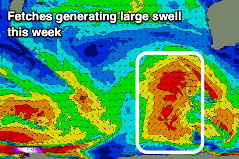 Wednesday still looks like a lay day as a vigorous mid-latitude front projects fresh to strong W/SW winds into all coasts, but also brings an increase in building windswell and SW groundswell.
A fetch of strong to gale-force SW winds will project up towards us, with the swell expected to peak Thursday morning to 6-8ft, 3ft in Mandurah and 2-3ft Perth.
With the clearing of the front off to the east through Wednesday evening we'll see winds quickly swing back offshore on Thursday morning and out of the E/SE-E, giving into afternoon sea breezes.
The follow up polar fetch possibly bringing a secondary S/SW groundswell now looks to be a touch weaker and later forming, with a reinforcing swell expected to just soften the easing trend slowly through Friday with great E'ly offshore winds.
The South West should still be 6ft Friday morning, 2ft+ Mandurah and 2ft Perth, smaller Saturday with less favourable winds.
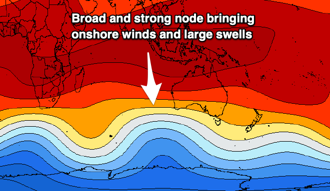
These less favourable winds will be linked to another strong mid-latitude front pushing up and into us on the weekend, the first of many as a broad, strong and stationary node of the Long Wave Trough develops across us.
This looks to bring large, windy onshore swells for Sunday through early-mid next week, but more on this Wednesday.