Smaller surf with strong offshore winds

Western Australia Surf Forecast by Craig Brokensha (issued Monday 24th February)
Best Days: Wednesday late morning onwards at swell magnets across the South West, Thursday swell magnets in the South West, Friday late morning south swell magnets in the South West
Recap
A small and clean start to the day Saturday across the South West, jacking in size quickly through the day as winds remained favourable for selected breaks into the afternoon.
Sunday was great with the swell cleaning up through the morning and easing back from the 6ft range in the South West, 2ft in Mandurah and 1-2ft in Perth.
Today was a touch smaller again but improving through the day across the South West with 4-5ft sets and clean conditions, 1-2ft further north.
This week and weekend (Feb 25 – Mar 1)
We've got smaller surf on the way this week with the current swell due to ease further tomorrow, topped up by a new mid-period S/SW swell across the South West Wednesday.
This swell is being generated by a late forming (in our swell window) frontal progression to our south-west with less than favourably aligned strong to gale-force W/NW tending W/SW winds.
 The swell won't impact the spots north of the cape with Mandurah and Perth remaining tiny.
But firstly looking at tomorrow and easing surf from the 4ft range is due across the South West, tiny and 1-1.5ft max in Mandurah and Perth.
The new S/SW swell should then provide 3-4ft+ waves across the south swell magnets in the South West.
Looking at the local winds and tomorrow isn't ideal with strong SE winds persisting all day, better Wednesday and improving mid-late morning and into the afternoon with a strong E/SE tending E breeze, holding into the afternoon while easing.
Thursday will see the swell easing with fresh to strong E'ly winds due to persist most of the day.
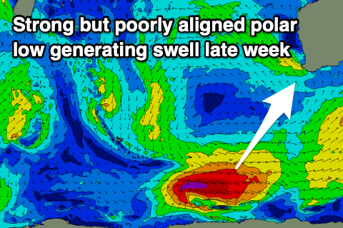
The only other source of swell for the period looks to be a small long-period S/SW groundswell for Friday afternoon, generated by a tight and strong but poorly aligned polar low, forming south-east of the Heard Island region tomorrow.
A polar fetch of severe-gale W/NW winds will be just within our swell window, but the resulting swell will only really impact the south swell magnets in the South West. It's not likely to be there at dawn but should build into the afternoon and reach 3-4ft+, then easing Saturday from 3ft to maybe 4ft.
Winds will swing more favourable for these south swell magnets Friday, NE early and then N'ly into the late morning and W/NW into the afternoon. Saturday looks poor though as the swell eases with W/NW winds.
Longer term there's nothing significant on the cards besides some small mid-period SW swell for mid-late next week. More on this Wednesday.
Comments
TC Ferdinand looks like a promising swell source for me and my dugong friends.
TC Esther is looking like a much better proposition for N swell. Latest guidance has it heading off NW cape as a severe TC
Yep Esther is the one to watch but it's still got a lot of travelling to do.
Go Esther! Send us a good day of right handers...