Windy though mostly offshore period, biggest this weekend

Western Australia Surf Forecast by Craig Brokensha (issued Friday 21st February)
Best Days: Tomorrow, Sunday morning, Monday morning in the South West, Wednesday in the South West
Recap
Strong offshore winds but still some good sized sets on the coast yesterday in the South West, better once the wind backed off, similar today but back to 3-4ft. To the north conditions were tiny, clean and hot through the day.
This weekend and next week (Feb 22 - 28)
A temporary low point in swell is expected at dawn tomorrow ahead of our new, long-period SW groundswell building through the day and peaking into the afternoon.
There's been no change to the expected size of this groundswell with the South West due to reach 6-8ft across the swell magnets into the afternoon, easing from the 6ft range Sunday morning. Mandurah should build to 2-3ft during the afternoon, 2ft+ across Perth with both being tiny in the morning, then easing from 2ft+ and 2ft respectively.
Looking at the local winds and a dawn E/NE breeze is due across the South West, tending N/NE and freshening through the morning, backing off into the afternoon and going variable. So there should be quality options most of the day. To the north similar breezes are expected, though more E/SE early.
Sunday should then see morning SE winds in the South West, E/SE to the north ahead of strong afternoon S/SE winds in the South West, S/SW to the north.
The swell will continue to ease into Monday with stronger E/SE winds across the South West, possibly SE at times, and E/SE to the north. The swell will be tending more southerly in direction though so it'll become tiny to the north and to 1-1.5ft or so, dropping from 4-5ft across the South West.
 Tuesday will be smaller again with similar windy SE conditions, not ideal.
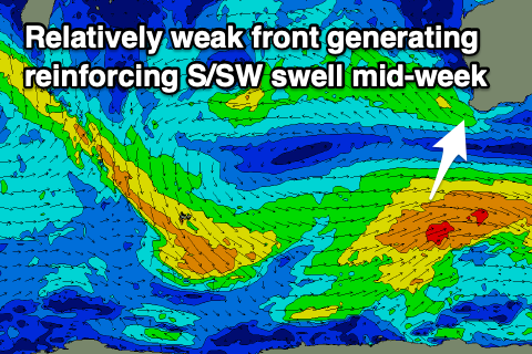
Come Wednesday the strong offshore winds will swing E/SE along with a reinforcing mid-period S/SW swell, generated by broad but relatively weak polar frontal system over the weekend.
Mandurah and Perth will remain tiny, but Margs should see a boost in size to 3-5ft, easing Thursday as winds tend more E.
Longer term, the storm track will be focussed towards Vic and SA as a strengthening node of the Long Wave Trough drifts east across the country. Behind this an upper block will see storms steered away from us.
One such storm strengthening late in our swell window on the polar shelf should produce a fun pulse of S/SW groundswell on Friday, but though only likely to 3-4ft or so in the South West, becoming tiny into the weekend. More on this Monday though. Have a great weekend!