Smaller, windier surf this period

Western Australia Surf Forecast by Craig Brokensha (issued Monday 13th January)
Best Days: Protected spots tomorrow AM, Thursday morning in the South West, Sunday morning in the South West
Recap
Fun and clean waves across the South West swell magnets Saturday morning with the surf easing from 3-4ft. Sunday was clean again with surf to 3ft as an inconsistent background SW groundswell steadied wave heights, while Mandurah and Perth were tiny all weekend.
Today the surf was still on the small side with less than favourable winds across all locations but a new swell is due later in the day (currently building), reaching 5-6ft in the South West, still only small to the north.
This week and weekend (Jan 14 - 19)
Later today's building swell is due to peak overnight and ease back through tomorrow from a fun 4-6ft across the South West, 2ft in Mandurah but tiny and to 1-1.5ft in Perth.
 Winds will be tricky though and fresh to strong from the S/SE-SE across the South West, similar to the north but a touch weaker in strength.
Wednesday will see similar if not slightly more SE angled winds across all regions but with smaller, leftover surf.
As tocuhed on in Friday's notes, smaller levels of mid-period SW swell are on the cards for the rest of the period with generally favourable winds each morning.
The first will be generated by a weak frontal system that's currently south-west of us with a broad fetch of strong W/SW winds moving through our swell window.
It should arrive for Thursday and favour the South West with sets to 3-5ft across the swell magnets, tiny in Mandurah and Perth, easing ahead of a slightly smaller reinforcing swell for Saturday, peaking into the afternoon (3-4ft+).
Winds on Thursday morning look great and E/SE ahead of sea breezes, less favourable and out of the S/SE on Friday and Saturday.
 Sunday should see a return to offshore E'ly winds with small easing sets from 3-4ft or so in the South West.
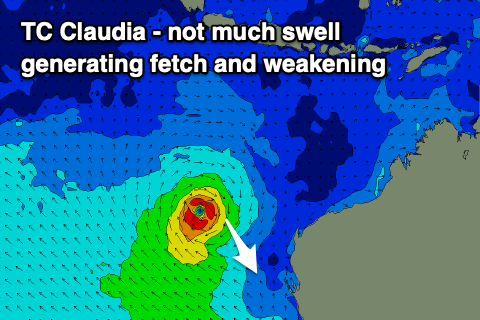
Looking to our north-west and Severe Tropical Cyclone Claudia has formed but the swell potential from this system is very minimal.
It will move rapidly west while weakening and have no decent swell generating fetch aimed through our swell window.
Longer term a slower moving but still relatively weak polar frontal progression looks to generate a fun a large W/SW groundswell for early next week, but the storm linked to it might push up and into the state bringing onshore winds. We'll have a closer look at this Wednesday.