Large, powerful swells keep on keeping on

Western Australia Surf Forecast by Craig Brokensha (issued Wednesday 11th September)
Best Days: Perth and Mandurah tomorrow morning, selected spots Friday morning, Perth and Mandurah early Saturday, Sunday, Monday
Recap
Light winds and clean conditions across all regions yesterday with an easing swell from 6-8ft in the South West, 2ft in Mandurah and 2-3ft across Perth.
Today everywhere is average to poor with onshore winds and a mid-period W'ly swell.
Today’s Forecaster Notes are brought to you by Rip Curl
This week and weekend (Sep 12 - 15)
A new mid-period W/SW swell should keep the South West humming around the 6ft+ range tomorrow, 2ft around Perth and Mandurah but winds will remain onshore and out of the N/NW across Margs, a little better and N/NE early around Perth and Mandurah.
Of greater significance is the large W/SW groundswell due into Friday and reinforcing bigger SW pulse expected Saturday.
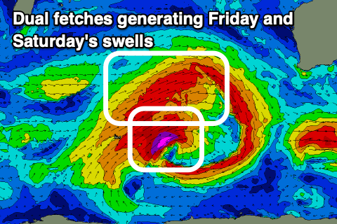 The vigorous frontal progression linked to this swell is currently west-southwest of us, generating a fetch of W/SW gales in our western swell window, producing Friday's initial large W/SW pulse.
A polar fetch of severe-gale SW winds are generating an additional large, long-period SW groundswell pulse for Saturday morning, while yet another cold front piggy-backing on the back of the progression Friday will generate an additional swell, slowing the easing trend Sunday.
Size wise, nothing has really changed from Monday with building surf to 8-10ft+ across the South West Friday afternoon, 3-4ft Mandurah and 3ft Perth, peaking Saturday morning to 10-12ft, 3-4ft Mandurah and 3ft Perth.
Winds early Friday as the swell starts to build look OK and out of the N/NE (E/NE Perth and Mandurah), N/NW into the afternoon and then W tending S/SW Saturday, though N/NE at dawn in Perth and Mandurah.
Sunday is looking better but not perfect with S/SE winds across all locations and easing large levels of W/SW swell from 8-10ft, 3ft and 2-3ft respectively across the state.
Monday will be excellent conditions wise with an E'ly offshore and further drop in size from 6ft, 2ft and 1-2ft respectively.
Longer term the models are indicating winter calibre polar storms moving through our swell window all this period, likely the result of the Sudden Stratospheric Warming event, but more on this Friday.