Easing surf with workable winds, and then large onshore run of swell

Western Australia Surf Forecast by Craig Brokensha (issued Monday 1st July)
Best Days: Tomorrow and Wednesday morning all locations, possibly Saturday morning Perth and Mandurah
Recap
Plenty of size left across the coast Saturday morning with workable bumpy 3ft waves in Mandurah, cleaner and 2-3ft in Perth, while Margs was poor and onshore. The swell was smaller Sunday and poor across all spots besides the early in Perth.
Today a large, long-period SW groundswell has filled in, XL but onshore in the South West, 3-5ft in Mandurah and building to 3ft+ in Perth.
Today’s Forecaster Notes are brought to you by Rip Curl
This week and weekend (Jul 2 - 7)
Today's XL SW groundswell is expected to ease back over the coming days and winds will be good for Mandurah and Perth but remain dicey for Margaret River and tend more variable. This will create cleaner though lumpy conditions with easing sets from 10-12ft+.
 An E/NE-NE offshore is expected around Perth and Mandurah with easing sets from 3ft+ at the former and 4ft in Mandurah.
Wednesday will become smaller and early moderate NE winds will freshen from the N/NE, favouring only selected breaks.
Moving into Thursday conditions will deteriorate rapidly as a weakening trough (earlier life as a polar front) moves in, bringing strong pre-dawn N'ly winds, shifting W/SW across all locations on about dawn.
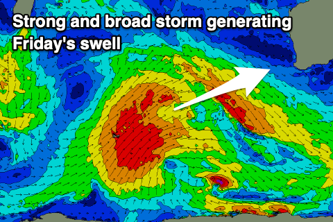
Currently this polar front is developing around Heard Island, with a fetch of SW gales forecast to be projected up towards Indonesia, weakening as it moves further north-east and closer towards us over the coming days.
A mid-period W/SW swell should be seen Thursday afternoon with the groundswell arriving out of the SW on Friday.
Size wise we're looking at 8ft to ocasionally 10ft waves across the South West, 3ft in Mandurah and Perth on Friday but with SW winds.
Unfortunately a small low moving up and into us Friday evening will bring onshore winds across all locations Saturday (possibly variable early in Perth and Mandurah, but well review this Wednesday) as the swell eases.
This unfortunately looks to be the start of a poor run of conditions but large stormy swells as a strong node of the LWT moves in and stalls across us. Therefore make the most of the cleaner conditions over the coming days.