Large to extra-large stormy swells

Western Australia Surf Forecast by Craig Brokensha (issued Friday 7th June)
Best Days: Protected spots Tuesday, Mandurah and Perth Thursday morning, all locations from Friday morning
Recap
Strong to gale-force N'ly winds and large, stormy building N-N/NW swells yesterday, easing back this morning with a W/SW change favouring a few selected spots for savvy surfers.
Today’s Forecaster Notes are brought to you by Rip Curl
This week and weekend (Jun 8 - 14)
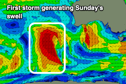
Buckle up, we've got nearly a week of large stormy surf and strong to gale-force onshore winds for the coming period as a strong node of the Long Wave Trough moves across us slowly.
 Tomorrow looks poor as a vigorous polar front approaching us from the south-west brings strengthening NW winds ahead of an afternoon W/SW change.
This polar front will project a great fetch of gale to severe-gale force winds through our south-western swell window, with the remnants of the storm due to push through on Sunday.
Wind strengths aren't expected to be as strong as forecast on Wednesday though we'll still see large stormy surf developing across all locations.
Size wise we're looking at onshore stormy surf to 12-15ft in the South West on Sunday with strong W/SW tending W winds, leaving no real decent options.
Mandurah and Perth look to come in around a stormy 4-5ft and 3-5ft respectively.
The secondary storm is still expected to fire up on the tail of the original front, projecting an additional fetch of gale to severe-gale W/SW-SW winds towards us Monday, moving in across us on Tuesday.
This will produce another XXL pulse of W/SW groundswell for Tuesday, with wave heights dropping back temporarily on Monday across all locations along with strong W/NW-W winds.
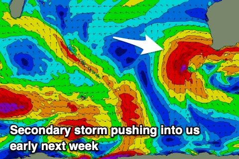 Tuesday morning should reveal 12ft+ waves in the South West, 4-5ft sets around Mandurah and 3-5ft waves in Perth as winds shift to the S/SW and remain strong. This should open up some better options in protected spots for experienced surfers.
We'll see the swell tailing off on Wednesday and winds will remain poor and out of the SW tending W/SW, as another front clips the state. A reinforcing S/SW groundswell is expected off this front on Thursday afternoon, possibly followed by another pulse Friday as winds slowly improve.
S/SW winds look to persist on Thursday across the South West, with a SE offshore further north around Perth and Mandurah along with easing 2ft and 2-3ft sets respectively.
A more variable E'ly offshore is likely Friday morning 6ft+ waves in the South West, 2-3ft Mandurah and 2ft Perth.
A return to lighter winds and fun sized swells is then expected from next weekend as all the storm activity moves further east and onwards towards Victoria and South Australia. More on this Monday though, have a great weekend!