Back to back large swells this week with great conditions in selected spots

Western Australia Surf Forecast by Craig Brokensha (issued Monday 6th May)
Best Days: Protected spots in the South West tomorrow and Wednesday, and then each morning throug the rest of the period, Perth and Mandurah all days
Recap
Poor conditions with onshore winds and no decent swell Saturday, bigger but a mess yesterday. Perth and Mandurah saw light early winds out of the N/NE yesterday with peaky and workable 2-3ft waves out of the west.
Today the swell is up further with onshore 6-8ft waves in the South West and 3-4ft in Mandurah and continuing at 2-3ft in Perth. We should see a stronger groundswell arriving through the late afternoon as winds remain onshore.
Today’s Forecaster Notes are brought to you by Rip Curl
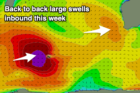
This week and weekend (May 7 – 12)
Today's large increase in swell is mostly mid-period and strengthening groundswell energy, but we should see the largest and strongest pulse of energy filling in later today and peaking tomorrow morning across the state.
The swell was generated by a strong mid-latitude low projecting a fetch of W/SW gales towards us, with the South West due to offer 10-12ft surf tomorrow morning, 3-5ft waves in Mandurah and 3-4ft sets in Perth.
 Winds are expected to remain onshore but weaker across the South West tomorrow and out of the S/SW, though more moderate in strength, with excellent offshore E/NE winds around Perth and Mandurah, shifting NW and then W but without too much strength.
The swell will ease steadily through the day, back further from 6ft to occasionally 8ft Tuesday morning in the South West, 3ft in Mandurah and 2-3ft in Perth with morning S/SE winds, tending a little more SE around Perth and Mandurah.
Thursday will be much cleaner across the South West as winds tend E-E/NE as the swell continues to drop, though a really fun 4-5ft across the magnets and 2ft on the sets in Mandurah and 1ft to maybe 2ft in Perth.
Our new long-range and very inconsistent W/SW groundswells for later in the day Thursday and Friday morning are still on track.
These were generated by a very significant storm that developed south of South Africa last week continuing to move slowly east through our swell window over the weekend. The system is now weakening around the Heard Island region, with two seperate long-period W/SW groundswells due to move in later this week.
The first should arrive Thursday and kick later in the day to 6-8ft across Margs by dark, 2ft in Mandurah and Perth along with hopefully light S/SE winds.
The secondary groundswell is due on Friday and should provide slightly more consistent 10-12ft sets in the South West, 3-4ft waves in Mandurah and 2-3ft in Perth. Winds are a little touch and go with the size of the swell and out of the E/NE-NE, tending more N'th though weakening.
Saturday looks to play out similar along with a reinforcing SW swell maintaining 6ft+ sets in the South West, 2-3ft in Mandurah and 2ft in Perth.
Longer term there's plenty more SW groundswell energy on the cards into next week as the Southern Ocean fires up, with a conveyer belt of polar fronts due to move through our swell window.
Winds look light and generally favourable for these swells, but more on this Wednesday.