Excellent Friday, with XXL surf into early next week

Western Australia Surf Forecast by Craig Brokensha (issued Wednesday 10th April)
Best Days: Friday morning, early Saturday morning, protected spots Wednesday, Thursday morning
Recap
Pumping waves across the South West yesterday morning with a gusty but easing offshore wind and solid S'ly groundswell to 6ft or so on the exposed reefs, but only small and to 1-2ft in Mandurah and 1-1.5ft in Perth.
Today the swell has dropped further and early variable winds created good waves across the South West for the dawn session, tiny to the north.
Today’s Forecaster Notes are brought to you by Rip Curl
This week and weekend (Apr 11 - 14)
Tomorrow will be a lay day with freshening W/NW tending SW onshore winds associated with a weakening low moving in from the west-southwest and no new swell until later in the day.
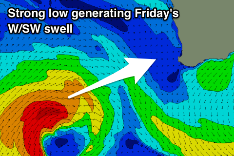 Friday is still looking excellent as the large W/SW groundswell from the low fills in. This low formed north-west of the Heard Island region at the start of this week and has since projected east-northeast through our western swell window while generating a fetch of strong to gale-force W/SW winds.
The low will weaken while approaching us today and tomorrow, dipping south-east allowing a high to move in Friday, swinging winds offshore out of the E/SE.
The swell will be solid from early morning but likely peak during the middle of the day with large consistent 8ft surf across the South West, 3ft in Mandurah and 2-3ft in Perth.
There is now a window of clean conditions expected Saturday morning as the swell eases with an E/NE-NE offshore shifting NW into the afternoon. Margs should still be a good size and easing from 4-6ft, 2ft+ in Mandurah and 2ft in Perth.
Winds will strengthen further from the W/NW on Sunday and into early next week as a strong node of the Long Wave Trough moving in across the state directs back to back polar fronts up and into us.
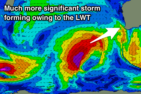 The first system will be quite significant with it forming around the Heard Island region this Friday evening, projecting a fetch of severe-gale to storm-force SW winds up through our western swell window over the weekend, moving in across the state through Monday.
An XXL long-period W/SW groundswell should be generated, building Monday and peaking Tuesday though with a strong W/NW breeze as the secondary system pushes up and into the state.
This will produce a secondary XL SW groundswell for Wednesday with better S/SE winds as a high moves in quickly. Thursday looks great as well as the swell eases with morning offshores, but more on this on Friday.