Large swell pulses, though onshore through next week

Western Australia Surf Forecast by Craig Brokensha (issued Friday 30th November)
Best Days: Sunday morning in the South West and Mandurah, Monday morning South West
Recap
Building surf yesterday but with generally unfavourable winds, while today is much better with the swell hanging in there under early offshore winds. 6-8ft across Margs, 2-3ft in Mandurah and 2ft in Perth.
Today’s Forecaster Notes are brought to you by Rip Curl
This weekend and next week (Dec 1 - 7)
We'll see this morning's swell back off into the afternoon and further tomorrow morning, but a new large S/SW groundswell will quickly take its place.
This is being generated by a strong low that's formed south-west of us, with a fetch of severe-gale W/NW-S/SW winds just within our southern swell window.
This will produce a good long-period S/SW groundswell for tomorrow afternoon, building to 6-8ft into the afternoon across the South West, 2ft+ in Mandurah and 1-1.5ft in Perth but winds will be onshore as a front off the low clips the state, bringing S/SW winds, that may tend S'ly for a period early around Mandurah and Perth.
 Sunday looks much better with a SE offshore around Margs, E/SE across Mandurah and Perth along with rapidly easing surf from 5-6ft, 2ft and 1-1.5ft respectively.
Monday will be cleaner again with E/SE offshores but smaller and easing from around 4ft, tiny to the north.
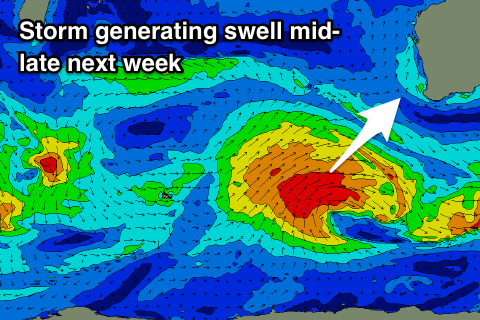
We'll see a relatively unstructured frontal system moving in from the Indian Ocean Sunday, forming into a deep low south-west of us early Monday and generating a fetch of W'ly gale to severe-gale tending SW winds through our swell window before projecting up and towards us while weakening mid-next week.
This should produce a large SW groundswell for Wednesday and Thursday, building and reaching the 6-8ft range again across the South West, 2ft+ in Mandurah and 1-2ft in Perth.
Winds don't look ideal Wednesday as the swell builds, while a mid-latitude front pushing in Thursday will keep conditions well below par.
It looks like mid-latitude fronts will continue to spoil conditions into next weekend, but more on this Monday. Have a great weekend!
Comments
Great work on the new/revamp web site
average sums it up really, southerly pattern showing no signs of ending.