Only one decent day of surf this week

Western Australia Surf Forecast by Craig Brokensha (issued Friday 9th November)
Best Days: Wednesday morning South West magnets and Thursday for desperate surfers
Recap
Small bumpy surf across the South West Saturday morning, tiny to the north.
A new S/SW groundswell filled in through the day yesterday but conditions were still average across the South West, with the swell too south and tiny to the north.
Onshore winds and a drop in swell have resulted in another lay day today, cleaner to the north though still tiny.
Today’s Forecaster Notes are brought to you by Rip Curl
This week and weekend (Nov 13 - 18)
The surf will remain small to tiny over the coming days, with poor winds tomorrow, much better Wednesday with a peak in size.
S/SE breezes are due tomorrow morning across Mandurah and Perth but with no size, while Margs will see onshore S/SW winds.
A new mid-period SW swell is due to build tomorrow afternoon and peak Wednesday morning, generated by a pre and post-frontal fetch of strong winds through our swell window the last couple of days.
Size wise we'll hopefully see 4-5ft sets across the South West swell magnets, 1-1.5ft in Mandurah and 1ft in Perth and with a great fresh offshore E/SE wind, holding nearly all day north of Margs, tending S/SE in that region through the afternoon.
 Winds look good again Thursday morning and offshore from the E/SE but the swell will be small and fading, tiny into Friday and clean again.
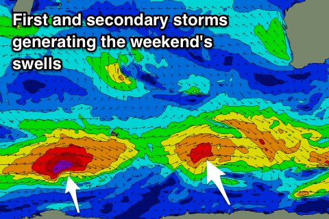
Later in the day Friday and more so Saturday a small new mid-period SW swell is due, with a secondary better and stronger pulse for Sunday afternoon.
These swells will be generated by small polar fronts developing west of the Heard Island region and skirting the polar shelf while generating W/SW fetches of gales, with the secondary system seeing severe-gale-force winds.
The first swell for Saturday morning should come in at 3-5ft across the South West, tiny to the north, with the second swell building to 5-6ft+ in the South West, 2ft in Mandurah and 1-1.5ft in Perth, but a surface trough moving in from the west will spoil conditions.
It'll bring NW to SW winds on Saturday, more onshore from the W/SW Sunday creating average conditions.
Longer term there's still nothing significant on the cards for our region, but more on this Wednesday.