Poor across the South West, windows to the north

Western Australia Surf Forecast by Craig Brokensha (issued Monday 3rd July)
Best Days: Saturday across the South West, Perth and Mandurah Thursday and Saturday mornings
Recap
Stormy building surf across the state Saturday, with a peak in S/SW groundswell Sunday morning to 8-10ft but with strong S'ly winds. This left protected locations with the best conditions.
Further north the surf was cleaner with good easing 3-4ft surf around Mandurah and 3ft waves up in Perth.
Today the swell has continued to ease and an early light wind failed to develop across the South West, with a front pushing in from the west. Perth and Mandurah were cleaner with leftover 2ft sets.
This week and weekend (Jul 4 – 9)
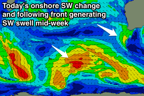
Today's onshore change, linked to a small front pushing up and into us, will linger into tomorrow with onshore S/SW tending W/SW winds due across the South West, while Perth and Mandurah should see early light offshores.
A new long-period S/SW groundswell will build through the day from a slow start at dawn, generated by a vigorous polar low late last week and over the weekend.
Satellite observations confirmed a great fetch of storm-force W'ly winds being generated in our swell window, with the low moving further east while weakening over the weekend.
 The swell should build to a strong 6-8ft+ across the South West into the afternoon, with 2ft+ sets in Perth late in the day.
A drop is then due into Wednesday but a stronger cold front approaching from the south-west will bring with it fresh W/SW tending SW winds.
This front while not overly strong will bring with it a large increase in mid-period SW swell for Thursday (with building stormy SW windswell ahead of it Wednesday).
We should see 6-8ft surf both days across the South West, with 2-3ft waves around Perth, easing back through Thursday afternoon.
Winds will continue to linger from the S/SW across the South West Thursday, with lighter S/SE winds a possibility around Perth and Mandurah early.
There'll be no let up to the onshore winds into the end of the week, with a similar but weaker front expected to move into us on Friday.
This looks to deliver another mid-period SW swell for later Friday and Saturday with W/SW tending SW winds on the former and better S/SE breezes as the swell eases Saturday.
At this stage it looks like we'll see easing 6ft+ waves in the South West and 2ft+ waves around Perth.
Longer term there's nothing significant due for the rest of the weekend or earlier the following week, with some large onshore stormy swell on the cards for mid-late the following week. More on this Wednesday.