Average forecast period for WA

Western Australia Surf Forecast by Craig Brokensha (issued Monday 19th June)
Best Days: Friday, Saturday and Sunday in the South West
Recap
Great surf Saturday with a new SW groundswell and offshore winds, coming in around 6ft with the odd bigger one across the South West and 2ft further north.
The swell eased back from the 4-6ft range and 2ft respectively Sunday morning cleanest early before winds swung a little more north.
Today an onshore wind and small swell have created poor conditions in the South West, with smaller cleaner options to the north.
This week and weekend (June 20 – 25)
Into tomorrow we'll continue to see the surf drop, with a new small SW groundswell still on the cards for Wednesday. This has been generated by a weak polar frontal system, while some weak mid-period S/SW swell on the cards for tomorrow afternoon is off the cards due to the front not pushing up towards us anymore.
Instead we'll see small fading surf Tuesday with strong SE winds across the South West and E/NE winds to the north as a small low develops off the south-west corner of the state.
Wednesday's swell should provide inconsistent 3-4ft+ sets across the South West, tiny to the north and with poor winds as the lows eastern flank interacts with the coast. N'ly tending NW winds are due across Margs, with W/SW to W/NW winds further north. The low may generate some weak windswell for the Perth region, but we'll have to have another look at this Wednesday.
 Moving into the end of the week we've got some new swell on the cards, but out of the S/SW.
The first pulse for Thursday will be more mid-period energy and without much size, generated by weak polar frontal activity skirting our southern swell window. Winds should swing back offshore for this swell as the low starts to slowly weaken off our coast, but we're only looking at 3-4ft sets in the South West and tiny waves again to the north not above 1ft.
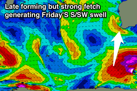
Of greater importance is some larger long-period S/SW groundswell for Friday.
This will be produced by a vigorous polar frontal progression forming late in our southern swell window, with a fetch of severe-gale to storm-force winds developing to our south-southwest Wednesday evening and Thursday.
Exposed south facing breaks should see good 6ft sets through all of Friday, much smaller elsewhere while Perth isn't expected to see any decent size with the south in the direction. 1-1.5ft sets if we're lucky.
Strong SE winds will create less than ideal conditions at these south magnets across the South West though, a touch weaker as the swell eases into Saturday.
Longer term there's still nothing major on the cards as a large blocking high deflects frontal activity away from us. There'll also be no decent long-range energy to take advantage of. More on this Wednesday.