Back to back large swells with good conditions

Western Australia Surf Forecast by Craig Brokensha (issued Friday 5th May)
Best Days: Saturday, Sunday morning, later Tuesday, Wednesday, Thursday morning
Recap
Compared to the run we've had, yesterday and today were quite average with onshore winds. An increase in swell was seen this morning across the South West, tiny to the north.
Winds are easing across the South West and our large W/SW groundswell has started to really kick into gear. Exposed spots are seeing 6-8ft sets and we shoud continue to see the surf reaching 10ft later today.
This week and weekend (May 6 – 12)
The W/SW groundswell currently building across the state should peak tomorrow morning with 10ft to occasionally 12ft sets across exposed breaks in the South West, with 2-3ft waves in Perth.
Winds will continue to improve as the frontal progression linked to the swell moves east, resulting in offshore E'ly tending E/NE winds, NE around midday before tending variable into the afternoon. This swell will only be for experienced surfers, so if you're not sure, don't enter the water.
Sunday will be much smaller, likely half the size and clean early with an E/NE offshore, but a more N'ly wind will develop by midday, easing off later.
We're still expected to see variable winds early Monday but there won't be much swell left across the coast at all.
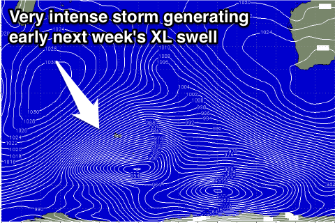 Our attention then shifts to the XL swell due Tuesday and Wednesday.
Currently west-southwest of Heard Island, a vigorous polar frontal system is developing, with a fetch of severe-gale to storm-force W/SW winds due to be projected north-east into the Indian Ocean, tracking east towards us while weakening and then across us Tuesday.
An XL W/SW groundswell should be generated, building rapidly through Tuesday to 12-15ft across exposed reefs in the South West and 3-4ft in Perth later in the day.
The swell is due to peak overnight, easing back from the 10-12ft+ range Wednesday morning and 3ft in Perth.
Conditions are looking much better now, with Tuesday's front bringing W/SW tending S/SW winds, clearing off to the east Wednesday resulting in E/SE offshores. We'll have to confirm this Monday, because if the system slows, we'll see less favourable S/SE breezes.
Longer term we may see a new large SW groundswell next weekend but more on this Monday. Have a great weekend!