Large swells persist but with variable winds

Western Australia Surf Forecast by Craig Brokensha (issued Monday 17th April)
Best Days: Tuesday, Wednesday Perth and Mandurah, Thursday morning, Friday morning, Saturday protected spots, Sunday morning
Recap
Not much down time between swells across the South West with the arrival of a large new S/SW groundswell through Saturday but with less than ideal winds (best for protected spots). Perth was tiny and also bumpy.
The swell eased back into Sunday to 5-6ft across the South West with cleaner conditions while Perth saw fun small 1-2ft sets.
Today the surf was smaller again and with average S'ly winds across Margs and tiny bumpy waves to the north.
This week (Mar 18 – 21)
The outlook for our region remains active with tomorrow's large and powerful SW groundswell on track.
 This swell was generated over the weekend by a vigorous polar low firing up south-east of Heard Island. Satellite observations have confirmed a fetch of storm-force 50-55kt winds produced on an already active sea state and we'll see the swell arriving around dawn tomorrow morning and coming in large all day.
Later today ahead of this some new SW swell from pre-frontal W/NW gales is expected, but conditions will be poor.
Exposed reefs around Margs should see 10-12ft surf (if not for the odd bigger one) with 2-3ft sets developing around Perth mid-late morning.
Conditions look great early with a light E/SE offshore wind, but an approaching front will bring onshore winds from midday/early afternoon from the W/NW around Margs and SW Perth.
Wednesday isn't looking too flash with a lingering onshore wind and smaller swell across Margs. Perth should be clean early with 2ft sets.
Tomorrow's approaching front will bring with it a new large W/SW groundswell for Thursday. A fetch of gale to severe-gale W/SW winds are forecast to be generated through our swell window, with the swell kicking later Wednesday ahead of a peak Thursday morning.
6-8ft sets are due across the South West early Thursday, with 2ft+ waves around Perth (2-3ft Mandurah) along with a variable wind from the E/NE ahead of afternoon sea breezes.
A drop in swell will be seen into the afternoon, smaller Friday morning with light morning offshore winds from the SE.
Another two strong approaching mid-latitude fronts should generate another large W/SW groundswell event for Friday afternoon and more so Saturday morning.
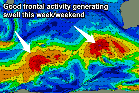 An initial fetch of gale to severe-gale W/SW winds will be overridden by a slightly stronger and higher riding front, generating the largest increase in size Saturday morning.
Large consistent surf in the 8ft+ range should be seen across Margs Saturday morning with 3ft waves further north, easing through the day and further Sunday. Unfortunately winds look S'ly Saturday, more offshore Sunday but the models are diverging a little surrounding this.
We'll have a closer look at this on Wednesday, but beyond this smaller surf with offshore winds are due into early next week.
Comments
Hey Craig,
Will winds be clean (E-SE) to the north tomorrow morning? Say around Lancelin area?
Cheers for the great forecaster notes as always!
Yep, should be SE tending E/SE before sea breezes kick in.
Pumping across WA today..