Plenty of swell with windows of good and great conditions

Western Australia Surf Forecast by Craig Brokensha (issued Monday 10th April)
Best Days: Most days over the period
Recap
Average conditions Saturday with onshore winds across the South West but plenty of swell, while the the north it was cleaner, but tiny.
Sunday was excellent with a strong new S/SW groundswell and offshore winds.
Today the swell was still solid but a touch smaller, with clean conditions across all regions through the morning again.
This week (Mar 11 – 14)
Hi everyone, it's good to be back on board after a couple of weeks away overseas.
As Ben touched on last week, we're due to see a large long-period but inconsistent SW groundswell building tomorrow across the state, peaking into the afternoon.
With most of the swell production occurring west of Heard Island, there'll be long waits for sets, but we should see Margs building to 6-8ft, with 2ft sets around Mandurah and Perth.
 Conditions will deteriorate with the new swell though, with a morning E/NE offshore giving into a weak but increasing W'ly change around midday.
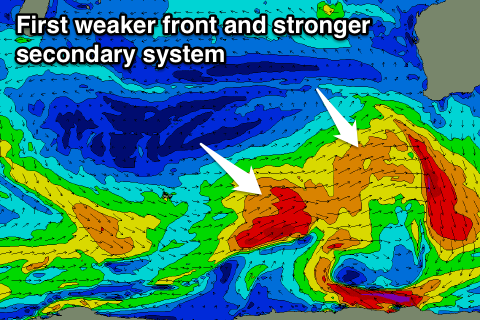
This onshore change will be linked with a cold front approaching from the south-west, generating a fetch of strong to sub-gale-force SW winds.
A mid-period but moderate sized SW swell is due off this system, building through Wednesday afternoon ahead of a peak Thursday morning. Margs should see 4-6ft sets with 1-2ft waves around Perth, ahead of a stronger S/SW swell through the day Thursday.
This will be generated by a stronger polar front firing up on the tail of the initial front, with a fetch of W/SW gales being aimed through our southern swell window.
We should see a moderate to large S/SW groundswell from this fetch, building to a consistent 6ft across exposed breaks, if not for the odd bigger one later in the day, easing from 5-6ft Friday. Perth should see 2ft sets continuing.
Winds Wednesday morning should tend more variable early, but we'll be in between swells, with afternoon sea breezes spoiling the building swell.
Thursday looks great with E/SE offshores ahead of afternoon sea breezes. Into Friday as the swell eases, a small surface trough developing offshore looks to swing winds to the S/SE at some stage during the morning, but we may see offshore winds at dawn.
This weekend onwards (April 15 onwards)
A low point in swell activity is due Saturday morning as winds freshen from the SE, but into the afternoon a new long-period S/SW groundswell is due to fill in.
A strong polar low will form in our southern swell window, with core wind speeds forecast to reach the storm-force range. The low will be a little funky in structure, but we should still see a good pulse of swell for Saturday afternoon, kicking back to 6ft across the exposed reefs, and 1-1.5ft around Perth later in the day.
A slight drop in size is expected on Sunday morning, but another strong front projecting towards us Sunday afternoon should kick up some new S/SW swell later in the day and more so Monday morning.
Winds at this early stage look less than ideal and from the S/SE Sunday but offshore Monday. We'll review this Wednesday though so check back for the latest then.
Comments
Epic waves this morning. Love this surfcam! So clear and crisp (shame about the first image, camera has auto-focus and wasn't quite locked in.. but how's the fella bottom turning on the right!).