Average end to the week, good Saturday, and again Monday

Western Australia Surf Forecast by Craig Brokensha (issued Wednesday 22nd March)
Best Days: Later Friday in the South West, Saturday morning, every morning next week
Recap
Good fun waves around 3-4ft across the South West yesterday, although a little bumpy with the strength of the offshore wind, while tiny surf was seen to the north.
Today the swell was a touch stronger across the South West, but winds more from the SE, creating bumpier conditions. To the north a tiny windswell with onshore winds was breaking.
The low responsible for the onshores to the north has now slipped south and we're seeing average conditions across all locations.
This week and next (Mar 23 - 31)
Don't bother about surfing tomorrow, as we'll see onshore S/SW winds from the backside of the weakening low passing across us and small amounts of weak S/SW windswell.
Into Friday though winds should improve slightly, tending S/SE across all locations and persisting into the afternoon across the South West.
Some new SW groundswell will also arrive, with a small pulse for Friday morning, ahead of a stronger long-period groundswell event into the afternoon.
We discussed the long-period swell Monday, generated by a vigorous Southern Ocean storm, but the small increase ahead of it will be from a pre-frontal fetch of W/NW winds racing ahead of the low.
3-4ft sets are due across magnets shortly after dawn, tiny to the north, while the stronger groundswell should build later to 6ft on the sets.
A peak is still expected on Saturday with 6-8ft waves across the South West and 2ft+ waves around Perth. Conditions look great with a light offshore E/SE breeze, tending variable ahead of mid-late afternoon sea breezes/or an approaching change if it beats it.
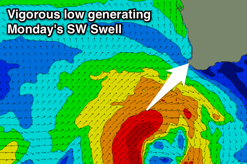 Now, as talked about last update, this approaching change will be due to a strengthening mid-latitude low to our south-west under the influence of the Long Wave Trough.
The strength and longevity of this low within our swell window has been lessened slightly and with this we won't see an XL swell developing, more a large SW groundswell event.
We should see mid-period energy building Sunday but with poor W/SW tending S/SW winds, ahead of a peak Monday morning to 8ft+ across Margs and 2-3ft in Perth.
Conditions will clean up Monday as the low pushes away from us, resulting in light SE offshores (E/SE around Perth) ahead of SW sea breezes.
Tuesday should see similar winds but smaller easing surf.
Longer term and another large S/SW groundswell is expected mid-week, generated by a storm at polar latitudes forming in the Heard Island region, projecting east-northeast through our southern swell window. We should see sets in the 8ft range as this swell fills in Wednesday under SE breeze, cleaner as it eases into the end of the week, but more on this Friday.