Great waves tomorrow, XL swell for the weekend

Western Australia Surf Forecast by Craig Brokensha (issued Wednesday 15th March)
Best Days: Thursday morning, early Friday in the South West, Sunday morning protected spots, Monday morning
Recap
Poor waves on all coasts yesterday with strengthening onshore winds and a building windswell.
Today a much larger W/SW groundswell event is breaking across the South West with 12-15ft waves along with decent winds for protected spots, while Perth and Mandurah saw solid sets and workable waves at selected locations.
This week and weekend (Mar 16 - 19)
The severe low responsible for our current XL swell in the South West and large swell further north will is currently weakening while pushing through the Bight, resulting in easing surf and improving conditions tomorrow.
 We'll still see large 6-8ft waves at dawn tomorrow, 2-3ft around Perth and Mandurah, easing steadily through the day. Conditions are still looking excellent with straight offshore E'ly winds, tending E/NE ahead of sea breezes.
Friday looks smaller and only around 3-4ft in the South West, tiny to the north along with early variable winds, ahead of sea breezes in Perth and increasing NW winds across the South West.
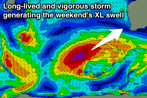
Now, into the weekend, our secondary XL swell event is coming along nicely.
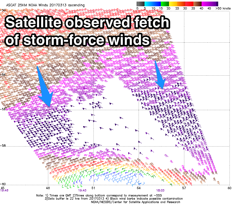
Since Monday a vigorous and slow moving polar low that developed south-east of South Africa has generating a fetch of severe-gale to storm-force W'ly winds through our far south-western swell window.
The low will continue to generate a fetch of severe-gale W/SW winds through our swell window over the coming days, projecting north-east towards us while slightly strengthening in a 'captured fetch' like motion.
This will see the swell travelling at a similar speed compared to the storm that's generating it, resulting in a larger than normal wave growth.
 We're actually due to see two separate pulse of long-period SW groundswell from this storm, the first and least consistent (from the early stages of the low) Saturday morning arriving just ahead of the better pulse into the afternoon/evening.
We should see Margs building very strongly in size Saturday, reaching 12-15ft into the late afternoon/evening, easing from a slightly smaller size early Sunday.
Perth should build to 3ft later, easing from 3ft Sunday morning.
Winds are unfortunately still forecast to be onshore Saturday and from the W/SW tending SW, while Sunday will hopefully see morning S/SE breezes, favouring protected spots.
Monday looks much cleaner with an E/SE offshore but the swell will be much smaller and easing.
Longer term there's nothing significant next week, so plan around the coming days of swell.