Slow increase in swell, cleanest as it peaks

Western Australia Surf Forecast by Craig Brokensha (issued Wedensday 25th January)
Sign up to Swellnet’s newsletter and receive the West Australian Forecaster Notes and latest news sent directly to your inbox. Upon signup you'll also enter the draw to win a surf trip to P-Pass for you and a mate (this is the last week to enter). It doesn’t get much easier so click HERE to sign up now.
Best Days: Margs Thursday morning, both coasts Saturday morning, both coasts Monday morning, Margs Tuesday morning
Recap
Good clean waves around 4ft yesterday morning across the South West, small to tiny around Perth and Mandurah.
Today the surf was smaller and the wind back to the SE around Margs, straighter offshore to the north.
This week and weekend (Jan 26 – 29)
Our slow increase in SW groundswell energy over the coming few days is still on track with an initial increase tomorrow to 3-4ft in the South West due to be topped by a slightly bigger kick to 3-5ft Friday morning and biggest increase Saturday to 4-6ft.
This is being generated by relatively weak mid-latitude frontal activity to our south west, growing a little stronger and broader with each front.
Perth is due to be tiny, with Saturday revealing the most size to 1-2ft, possibly a little undersized at dawn.
Conditions tomorrow morning are looking decent across both regions with a light SE to possibly E/SE breeze in the South West and E'ly tending NE winds to the north.
Average S/SE breezes are expected on Friday, but Saturday is still the pick with a light offshore E/SE breeze around Margs, E/NE to the north.
Sunday isn't too good at all as an approaching mid-latitude low brings a S/SW change to all coasts.
 Next week onwards (Jan 30 onwards)
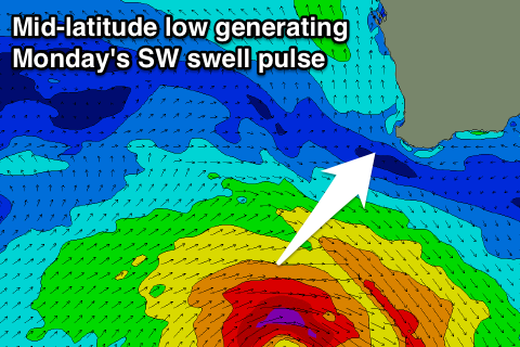
The low responsible for Sunday's change will generate a fun new SW swell for Monday.
The strength of this low has been increased a little, with a fetch of W/SW gales being generated in our south-western swell window as the low moves towards the Bight.
A peak is due Monday morning to a good 5-6ft in the South West, with 1-2ft sets around Perth, easing through the day.
A high moving in slowly in the wake of the low will result in SE offshores across all locations, more E/SE Tuesday as the swell continues to ease.
Longer term there's still nothing too major on the cards for us, so make the most of the coming swell pulses.