Large swell for the weekend, best out of the wind

Western Australia Surf Forecast by Craig Brokensha (issued Wednesday 21st December)
Sign up to Swellnet’s newsletter and receive the West Australian Forecaster Notes and latest news sent directly to your inbox. Upon signup you'll also enter the draw to win a surf trip to P-Pass for you and a mate. It doesn’t get much easier so click HERE to sign up now.
Best Days: Friday morning swell magnets in the South West, protected spots later Saturday in the South West, Sunday semi-protected breaks, Monday morning
Recap
Pumping waves yesterday with clean surf to 6ft in the South West, 2-3ft in Perth and Mandurah with offshore winds all morning, lasting a bit longer into the afternoon to the north.
Today the swell was a bit smaller but super clean again with hot offshores that will give into mid-late afternoon sea breezes.
This week through Boxing Day (Dec 22 - 26)
Tomorrow isn't worth worrying about, with a strong onshore change due to develop early tomorrow morning, bringing S/SW winds to all regions. A small to moderate sized SW groundswell is due to build through the day, with a slightly bigger but less consistent W/SW swell due to increase further through Friday.
The morning is due to be around 3-4ft in the South West and 1ft in Perth, increasing to 4-5ft+ and near 2ft on the sets respectively through the afternoon.
Unfortunately onshore sea breezes will be in by then, with morning SE-E/SE winds before the swell really kicks.
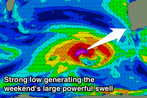
Of greater importance is a large SW groundswell due over the weekend.
Currently a vigorous low is developing north of Heard Island and we'll see a fetch of severe-gale to storm-force W/SW winds projected towards us tomorrow before the low stalls and weakens to our south-west.
This will result in a large long-period SW groundswell being generated, with the easing trend softened by the slow stalling and weakening of the low.
 Saturday morning is expected to start slow and with a fresh S/SE breeze, but from late morning the groundswell should start to show, building to a large 8ft+ into the evening and 2ft in Perth.
Unfortunately sea breezes will be well and truly in by then, with a late shift back to S/SE winds due around Margs.
Sunday morning should still see easy 6-8ft sets in the South West and 2ft waves around Perth, easing a touch through the day, smaller from 5-6ft and 1-2ft Monday morning.
Winds will be gusty but from the S/SE-SE most of Sunday favouring semi-protected breaks, with a straighter offshore E'ly Boxing Day morning ahead of a SW change.
Next Tuesday onwards (Dec 27 onwards)
Monday's change will be linked to a weakening front moving into us, with it tracking similar to the low generating the weekend's swell but being much weaker.
We should see a moderate sized SW groundswell arriving later Tuesday afternoon, peaking Wednesday morning.
Size wise we're looking at 5-6ft sets in the South West and 1-2ft waves in Perth but with S/SE winds. We'll have another look at this Friday though.