Improving conditions from Sunday with a large S/SW swell Tuesday morning

Western Australia Surf Forecast by Craig Brokensha (issued Friday 22nd July)
Best Days: Perth Saturday morning, both regions Sunday, and Monday morning (mid-late morning in the South West), both regions Tuesday and early Wednesday
Recap
Good fun waves around Perth and Mandurah yesterday morning with early favourable winds, while the South West was poor and onshore.
Today a large S/SW groundswell was filling in across all coasts with 8ft+ sets in the South West, 3ft+ waves around Mandurah and 2-3ft sets in Perth. Conditions were best to the north, with S'ly winds around Margs.
This week and weekend (Jul 22 - 29)
Tomorrow will be poor across the South West again with a fresh W'ly tending S/SW breeze and easing swell from today. Mandurah and Perth should be cleaner with light E/NE offshores and easing 2ft+ sets.
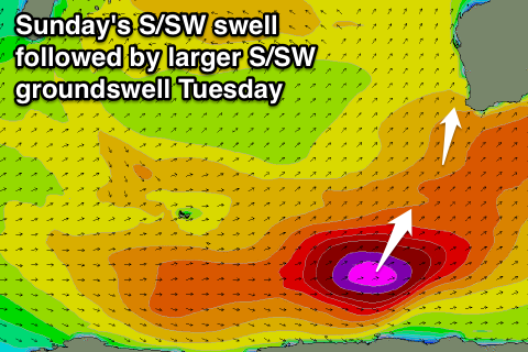
Our new S/SW groundswell for Sunday is tracking nicely with a fetch of strong to gale-force S/SW winds projecting north-northeast towards our South Coast today and early tomorrow.
A large S/SW groundswell will impact the South West, with 6-8ft sets due across exposed breaks, and building sets to 2ft in Perth into the afternoon.
Better conditions are due across the South West with a morning SE'ly, tending variable ahead of a possible late SW'ly. Perth and Mandurah should see offshore tending variable winds.
 As the swell eases Monday, conditions will remain clean to the north, but Margs now looks to see a weak front clipping the region just before dawn, with a moderate SW'ly likely. This should ease through the morning and become more variable before increasing a touch into the afternoon again.
Tuesday's longer period S/SW groundswell is now looking a touch stronger with severe-gale to storm-force W/SW winds developing this afternoon in the Heard Island region, projecting slowly east-northeast through our southern swell window before moving into the south coasts swell window Sunday evening.
A good large long-period S/SW groundswell should result, peaking Tuesday morning in the South West to a 8ft+ across the South West, with Perth likely to reach 2ft to occasionally 3ft through the day.
Conditions are looking good for this swell with light E/NE offshores across both the South West and further north, tending variable into the afternoon as the swell eases.
Wednesday will see NE tending N/NE winds as the swell eases.
Through the end of the week, moderate amounts of refracted SW groundswell are due across the state from a broad pre-frontal flurry of W/NW gales. Size off this doesn't look tot top 4-6ft across the South West Thursday afternoon and Friday morning with generally light winds.
Of greater significance is a stronger cold-outbreak occurring through the southern Indian Ocean mid-late next week. We are expected to see a very broad strong and prolonged period of frontal activity, with large to XL levels of W/SW swell on the cards from Sunday next weekend. We'll have a closer look at this Monday. Have a great weekend!