Large onshore swells for the period

Western Australia Surf Forecast by Craig Brokensha (issued Wednesday 13th July)
Best Days: Perth Friday morning, possibly Monday morning
Recap
A good new inconsistent groundswell yesterday to a solid clean 6ft across the South West and 1-2ft in Perth and Mandurah.
Today the swell was easing from a smaller 3-4ft in the South West and 1-1.5ft further north along with early offshores which are now swinging more northerly.
This week and weekend (Jul 14 - 17)
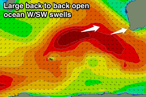
The coming period is looking really average with relentless onshore winds and a large mix of windswell and groundswell from Friday through most of next week. This is all related to a strong and pronounced node of the Long Wave Trough developing to our west.
Tomorrow morning the swell will bottom out and strengthening N'ly tending NW winds will kick up a building NW windswell.
This windswell is due to ease back through Friday as the front linked to the pre-frontal NW fetch moves across us,
 With this winds will ease into Friday morning but remain onshore from the W/NW to NW across the South West, while Perth will see an early N/NE'ly. Some stronger mid-period W/SW groundswell is also due through the morning though from a broad fetch of trailing W/SW winds behind the front proper pushing towards us. This should create good 2ft to possibly 3ft sets across Perth and with that early N/NE'ly it will be worth a look
The South West will be larger and around 6ft+ but a mess.
Into the late afternoon a stronger W/SW groundswell is due from the earlier stages of the cold front, with a fetch of W/SW gales producing larger 8-10ft sets in the South West and 3ft waves in Perth, easing back a touch through Saturday.
Bursts of gale to severe-gale W/SW winds on top of each other will continue to generate large levels of W/SW groundswell through Sunday and Monday. The surf should ebb and pulse between 8-10ft Sunday, with larger pulse Monday morning to 10ft+ through the morning, easing back a touch into Tuesday.
Perth should ebb and pulse around the 3ft+ range with better 4ft sets through Sunday and Monday.
Conditions will remain poor though with a fresh to strong N/NW tending W/NW breeze Saturday and then W/NW winds Sunday.
Into Monday there is a bit of divergence regarding a mid-latitude low forming off our coast with EC showing offshore SE winds, while GFS has less favourable NE winds in-feeding, so we'll have to review this again Friday.
Once this low moves across us Tuesday though onshore winds are due again with more large swells from the SW on the cards for late week/next weekend. More on this Friday.
Comments
Sorry blokes but what the bloom'n hell is an EC and a bloody GFS? Onya!