Large stormy swell developing from the S/SW

Western Australia Surf Forecast by Craig Brokensha (issued Friday 8th July)
Best Days: Keen surfers protected spots later tomorrow and Sunday morning, protected spots Monday morning, Tuesday morning
Recap
Good clean conditions yesterday morning across the South West to 4-5ft, bumpier and to 2ft further north.
Today a front moving into us has kicked up a building stormy windswell across all coasts but there's no decent options for a surf.
This weekend and next week (Jul 9 - 15)
The front pushing into us today is weakening while forming into a low pressure system and with that we'll see the large stormy W/SW swell whipped up this afternoon easing off through tomorrow as winds shift to the S/SW and strengthen.
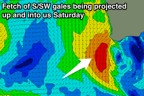 This will be related to the forming low projecting a fetch of gale to severe-gale up into the South West of the state.
This has been moving around a bit and after a downgrade Wednesday we're now looking at the swell being upgraded again.
Large and stormy 12ft+ surf is due to build into tomorrow afternoon, easing quickly from a similar size Sunday, while Perth should kick to 3-4ft, easing from 3-5ft Sunday morning.
Strong S/SW winds will unfortunately persist Sunday leaving no real decent options for a wave, especially with the southerly direction of the swell.
Winds are expected to swing back to the S/SE Monday morning but the swell will be all but gone as the low moves off to the east, leaving easing 4-5ft sets in the South West and 2ft waves in Perth.
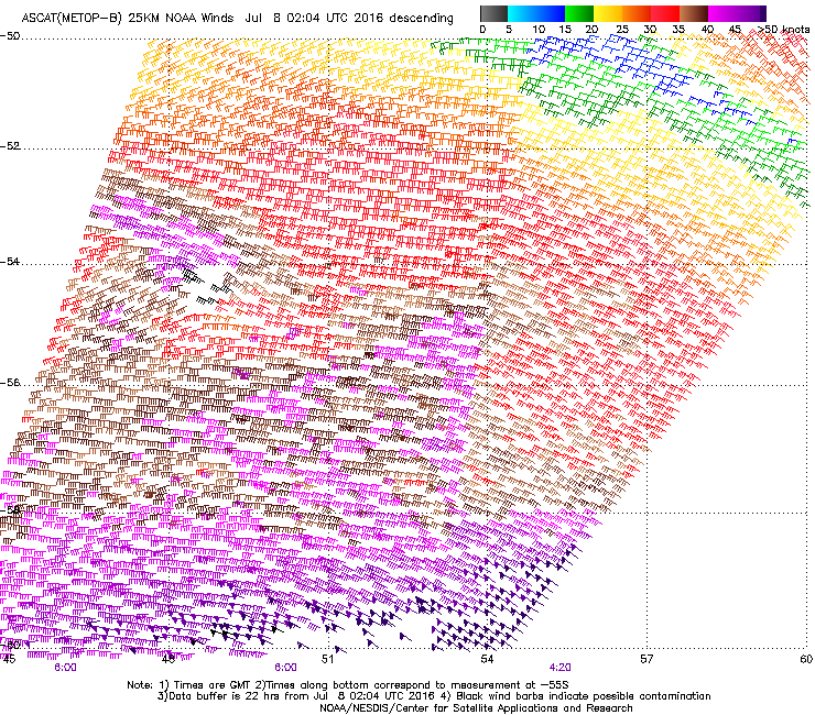 Tuesday should see a new inconsistent S/SW groundswell from a strong polar low that fired up west of Heard Island yesterday. A polar fetch of severe-gale to storm-force W/NW winds (right) have generated a good long-period but inconsistent groundswell.
The swell is due to arrive later Monday and peak Tuesday morning to 5-6ft+ across the South West and 1-1.5ft in Perth. The early will be the pick with an E/NE offshore, tending more NE into the afternoon.
The end of the week doesn't look too flash with easing surf under N/NE winds Wednesday and then stronger N/NW winds Thursday.
Longer term, the westerly storm track will become over active from this weekend through next week and beyond with a couple of large and one XXL swell on the cards for next weekend and early the next week. We'll have a closer look at this Monday. Have a great weekend!