Clean fun surf before onshores develop from Thursday

Western Australia Surf Forecast by Craig Brokensha (issued Monday 4th uly)
Best Days: Tuesday, Wednesday, early Thursday in the South West at spots that handle a northerly wind
Recap
Good clean conditions and 4-6ft of groundswell across the South West ahead of a new swell through the afternoon. Sea breezes created bumpy conditions though, with Perth coming in at a small clean 1-2ft through the morning.
Sunday saw the swell peak with large strong 8ft+ waves across the South West but with gusty S'ly winds limiting the best waves to protected spots. Perth was pumping with clean 2-3ft sets before the S'ly moved in around midday.
Today the swell was smaller and easing from 3-5ft but with straighter offshore winds in the South West and clean 1-2ft surf to the north.
This week and weekend (Jul 5 - 10)
Clean conditions will continue tomorrow as the swell eases back to a smaller 3-4ft in the South West with tiny 1-1.5ft sets across Perth. Offshore E/NE winds will persist so there's no rush to go the early.
Into Wednesday our new pulse of inconsistent SW groundswell is still on track with satellite observations picking up a good fetch of severe-gale to storm-force W/NW winds hugging the polar shelf over the weekend.
Margs should build to 5-6ft through the day with inconsistent 1ft to maybe 2ft sets around Perth. E/NE tending NE winds will favour some breaks over others on Wednesday with less favourable and strengthening N/NE tending N'ly winds Thursday as the swell eases.
From Friday we'll fall under quite a dynamic and significant weather event as cold front pushing up and into us from the west-southwest forms into a deep and powerful mid-latitude low.
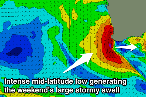 A fetch of W/SW gales will be projected into the state Friday kicking up an increase in windswell through the day followed by W/SW groundswell Saturday. Saturday afternoon will then see a large S/SW groundswell developing across the state as the low drifts east, bringing in gale-force S/SW winds.
Size wise the South West should build to a stormy 8-10ft Saturday afternoon with strong to gale-force S/SW winds. Perth should build to 3-4ft but with no decent quality.
The low will continue east through Sunday resulting in a dropping S/SW swell but along with fresh S/SW winds.
Monday looks cleaner as winds tend more S/SE but there'll be no decent swell left in the water.
Longer term there's nothing too significant as a large blocking high moves in and sits to our west, more on this and the weekend's developments Wednesday.