Fun swells, cleanest into the end of the week

Western Australia Surf Forecast by Craig Brokensha (issued Wednesday 13th June)
Best Days: Protected spots tomorrow and Wednesday, more exposed breaks Thursday and Friday
Recap
Workable waves across the Margs region Saturday with freshening NE winds and easing levels of swell, tiny further to the north.
The swell bottomed out Sunday morning with funky winds across most spots, remaining variable as some new W/SW swell kicked into the afternoon.
This swell held into this morning with 4-5ft sets across the South West and 1-2ft in Perth with 2ft+ sets around Mandurah. Variable winds created good conditioned again across most regions before onshores kicked in.
This week and weekend (Jun 14 - 19)
From tomorrow the first of a series of moderate to large sized SW groundswells are due, the largest expected on Thursday.
These swells have and are being generated by persistent but not overly strong polar frontal activity through our south-western swell window.
Tomorrow's pulse should offer 5-6ft sets across the South West and 1-2ft waves in Perth, easing into the afternoon and further Wednesday.
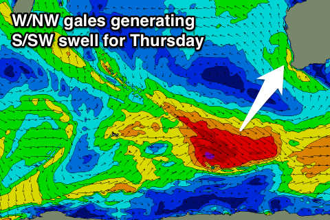 Thursday's pulse has started to be generated by a healthy fetch of pre-frontal W/NW gale to severe-gale W/NW winds moving through our south-western swell window.
A longer-period SW groundswell should result, filling in overnight Wednesday and peaking Thursday morning in the 6ft range across the South West and 1-2ft in Perth again.
A drop in size is due through the afternoon and further Friday, slowed by a reinforcing pulse of S/SW swell through the morning from a smaller polar low firing up on the back of the system generating Thursday's swell. 5ft sets should continue across the South West, easing a touch later, with no major size in Perth above 1-1.5ft.
Another reinforcing S/SW groundswell pulse is due Saturday to 3-5ft from trailing polar frontal activity, easing into Sunday.
Some funky W'ly swell may be seen into Sunday afternoon from an intense mid-latitude low forming north-northeast of Heard Island during the middle of this week.
Initially this low will be aimed way towards the Maldives and Seychelles, but a fetch of weakening W'ly gales should be aimed at us Thursday and Friday as it moves towards us.
Any size off this system will be met with NW winds as the low impacts the coast, creating poor conditions.
But coming back to the winds expected from tomorrow, and fresh and gusty SE-S/SE winds will favour protected locations, persisting into Wednesday. Thursday will be offshore around Perth but still SE/ESE around Margs, straighter E'ly Friday and then increasing from the N/NE Saturday.
Longer term there's still nothing too major on the cards, but more on this Wednesday.